- Causes of Future Sea Level Rise
- Elevation Maps
- Will we really lose all that land?
- Sea Level Rise Planning Maps
Rising Seas, Coastal Erosion, and the Takings Clause
By James G. Titus
Rising Seas, Coastal Erosion, and the Takings Clause: How to Save Wetlands and Beaches Without Hurting Property Owners (PDF, 121 pp., 2.2 MB) was originally published in the Maryland Law Review (1998), Volume 57, 1279-1399. From the report's Introduction section, Shall We Give Away the Shore? and Organization and Summary are available below online.
The full report also is available as a text only document for accelerated viewing and download – this version is minimally formatted and contains no graphics. For best download results, use your browser's "save as" function to retain the document as a text (*.txt) file.
In 2011, EPA published a rolling easement primer, to provide land owners, land trusts, and government agencies with a practical overview of how to implement a rolling easement policy. The newer primer provides a more thorough and up-to-date discussion of the possible objectives, legal approaches, and practical aspects of a rolling easement than this article. Nevertheless, this article provides a more thorough (albeit dated) argument for rolling easements over setbacks or laissez faire.
For additional reports focused on the implications of rising sea level, go to Sea Level Rise Reports.
Shall We Give Away the Shore?
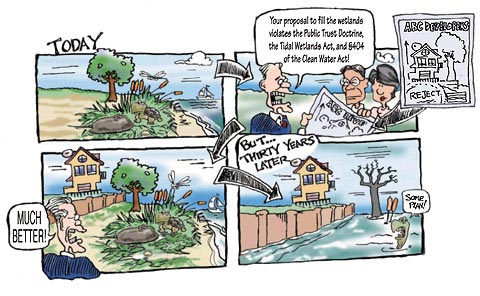
In the next century, the majority of America's publicly owned tidal shorelines could be replaced by a wall, not because anyone decided that this should happen but because no one decided that it should not. Throughout the United States, housing developments are being built just inland of the marshes, swamps, muddy shores, and sandy beaches that collectively comprise the "public trust tidelands." Because sea level is rising and most shores are eroding, the water will eventually reach these houses unless either the houses are moved or somehow the sea is held back.
The most common response has been to build a wall near the boundary between the private dry land and the public tidelands, saving the former but allowing the latter to erode away. Most states tacitly reward riparian owners who build these walls with sole custody of what had been the public shore by allowing the owners to exclude the public from the area inland from the wall, where there would have been a public beach or wetland had the wall not been built. In Maryland alone, more than three hundred miles of tidal shoreline have been armored in the last 20 years. This trend will accelerate if the greenhouse effect increases the rate of sea level rise.
We should not, however, paint all coasts with a single brush, because America has two types of coast: the ocean and the bay. Along the ocean, sandy public beaches dominate. Recognizing these beaches to be their "crown jewels," coastal communities and states protect them with a variety of policies that seem likely to ensure their survival in all but a few locations.
Farther inland lies the hidden coast that comprises 80 percent of our tidal shorelines. Part sand, part mud, and part vegetated wetland, these shores have diverse uses. Unlike the open ocean coast, our bay shores are gradually being replaced with walls of steel, stone, concrete, and wood [hereinafter bulkheads]. Where once a fisherman could walk on the public beach, there is no beach; and to walk along the bulkheads that replaced it, the fisherman must trespass in the backyards of the property owners who built them and appropriated for themselves the shore that once belonged to the public. Unlike the ocean resorts, where every block has a road leading to the beach, bayfront developments usually provide no access. Environmental regulations provide only temporary relief, having been designed as if shorelines and sea level are stable. Effective strategies for permanently keeping our natural shores apply to the open ocean – but not the hidden bay.
Why do we treat the ocean and bay coasts differently? Virtually every state has made the policy decision to keep its ocean beaches and not to privatize ocean shores that are currently open to the public. Yet policy makers have not addressed the loss of natural shores along the hidden coast. The rising sea has placed riparian owners' right to protect their homes on a collision course with the public's ownership of the intertidal wetlands and beaches.
Should we decide which portions of our bay shores will remain public and in a natural condition? Ironically, land use planning has provided state and local governments with a process for ensuring that some of the privately owned farms and forests remain as open space; but coastal states have no process for deciding how much of the publicly owned shore should remains in its natural condition, or even in public hands.
Organization and Summary
This paper examines land use planning options by which coastal states might retain some of their public trust tidelands in perpetuity—no matter how much the sea rises--at least in areas that have not yet been developed. A key assumption of this analysis is that policies should protect coastal property values. Any policy that fails to do so is likely to be unfair and inefficient, and to engender opposition sufficient to prevent implementation on the scale necessary to have a lasting effect. The analysis also assumes a preference for policies that rely where possible on the free market and that deal rationally with our inability to say how much the sea will rise.
Part II presents key background information. For example, a four-foot rise in sea level would inundate 7000 square miles of dry land in the contiguous United States--an area the size of Massachusetts. Although the sea is most likely to rise one foot every fifty years for the next few centuries, it could rise at twice that rate--or more. Part II outlines and analyzes three approaches for protecting tidelands: (1) prevent development in vulnerable areas seaward of a "setback line," (2) defer action, and (3) rolling easements, that is, policies that allow development but prohibit property owners from holding back the sea. Part II also identifies some combinations of these approaches, as well as options for retaining public shorelines even where bulkheads are built.
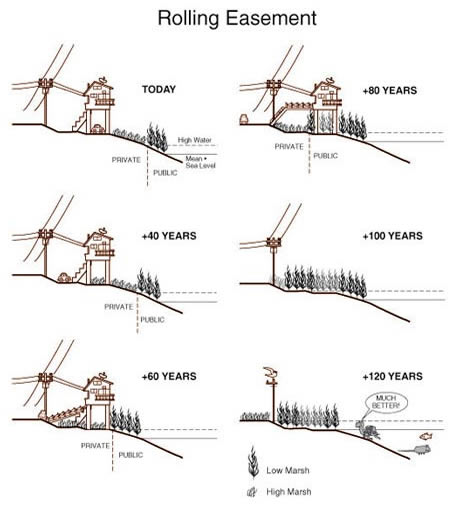
A rolling easement allows construction near to the shore, but requires the property owner to recognize nature's right of way to advance inland as sea level rises. In this case, the high marsh reaches the footprint of the house 40 years hence. Because the house is on pilings, it can still be occupied (assuming that it is hooked to a sewerage treatment plant-a flooded septic system would probably fail). After 60 years, the marsh has advanced enough to require the owner to park the car along the street and construct a catwalk across the front yard. After 80 years, the marsh has taken over the entire yard; moreover, the footprint of the house is now seaward of mean high water and hence on public property. At this point, additional reinvestment in the property is unlikely, and the state might charge rent for continued occupation of the home. Twenty years later, the particular house has been removed, although other houses on the same street may still be occupied. Eventually, however, the entire area returns to nature.
Setbacks have been employed along bay shores to limit pollution runoff and along ocean coasts to keep homes from being built in areas that are vulnerable to erosion or storms. In undeveloped areas where all the low land is within a few hundred feet of the shore, preventing or restricting development may be the best way to retain the tidelands. But purchasing an area the size of Massachusetts would be expensive; and regulations to prevent development in such a large area would be inefficient, unfair, and politically infeasible. Moreover, the need to draw a setback line on the map poses two practical difficulties: (a) sea level rise is uncertain; so defining the appropriate setback line is difficult; and (b) eventually the shore would retreat to any setback that is established, unless development were prevented in an area much larger than the land that is at risk in the next century. Deferring action will not save the tidelands unless future politicians are willing to buy or order the abandonment of this same land after it is developed.
Rolling easements seem more likely to succeed on a broad scale. These policies do not require a particular line to be drawn on the map. Their impact on current property values would generally be less than 1 percent. Governments could afford to compensate riparian owners; and even a failure to compensate them would impose a minor burden. Developers who deny that the sea will rise would view the policy as costing them nothing. Unlike setbacks, rolling easements allow landowners to decide how best to use their property between now and whenever the land finally erodes. Nevertheless, enforcement may be politically difficult. A combination of density restrictions, setbacks, and rolling easements would probably be more successful than relying on any single option.
Would these policies require compensation under the Takings Clause of the 5th Amendment? Part III examines that question, based on the assumption that property owners have the right to build a home and protect it from the sea. In areas where lots have already been subdivided, development would often be the only economically productive use of the land; so preventing development would require compensation. In areas that have not been subdivided, however, preexisting land uses may be profitable, in which case preventing development may not require compensation. Deferring action and subsequently requiring people to abandon their homes would almost always involve a taking if the homeowner is willing and able to protect the shore. Rolling easements, by contrast, would probably not require compensation, given their trivial impact on property values and the several decades that would pass before they had any actual effect.
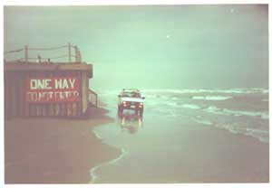 A single seawall can diminish the ability of Texas residents to drive along the beach. At this site near Corpus Christi, the rolling easement did not apply and only one-way traffic is allowed. |
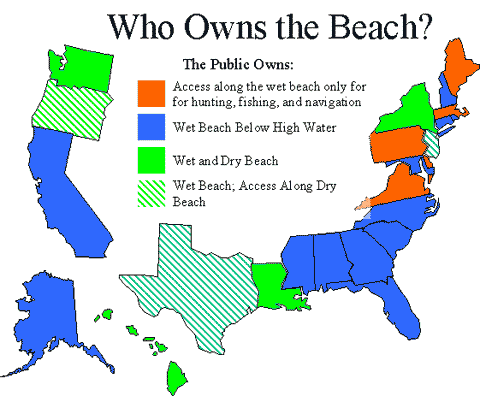
Part IV suggests that shorefront owners do not have a right to hold back the sea. For over one thousand years, the "law of erosion" has held that the boundary between public and private land migrates inland as shores erode; and there is no right to increase one's land at the expense of a neighbor. In fact, the term "rolling easement" originated with the common law of Texas. Along much of the shore, there is a public easement, that is a right to access along the beach. The courts recognized that if people were allowed to build seawalls along the shore, public access would be blocked. Therefore, the common law provided that this public easement would simply "roll" landward as the shore erodes.
Another ancient principle of property law, the "public trust doctrine" provides independent support for this view. Some portions of this doctrine are controversial, but no one disputes the rule that a state does not lose ownership of the shore unless it intends to do so. It follows that the state is never required to allow bulkheads that privatize the shoreline. Thus, rolling easements are a codification of the expectations that generally prevailed under the common law. This logic might apply to deferred action; but not if states waive their property interests by telling property owners that they have a right to hold back the sea.
 [D]
[D]Part of Florida's beaches are also open to the public under the doctrine of custom. In addition to the common law interest, the public has obtained the right to access along many shores through voluntary assignment of easements by riparian owners, as well as public purchases of shorefront lands and easements.
Part V briefly shows that the low cost of rolling easements also makes governments able to bypass the takings issue and simply purchase the easements from current land owners. This option is also available to developers and conservancy groups, and may be feasible even in areas that are already developed. This article concludes with options by which state, local, and private organizations could move the issue forward.
This study does not focus on a federal regulatory solution to this problem, because land use is a state and local responsibility. The federal government has had a paramount role in efforts to stop people from destroying coastal wetlands, because those wetlands are generally found within the ebb and flow of our coastal waters, where the federal government has always had jurisdiction. The survival of our coastal wetlands as sea level rises, however, depends on how people use land that is currently dry, and hence outside of federal jurisdiction. Nevertheless, the federal government could also help to ensure that wetlands survive rising sea level, both in its role as a major coastal landowner and in its many programs that foster research and policy implementation at the state and local level.
Rising Seas, Coastal Erosion, and the Takings Clause: How to Save Wetlands and Beaches Without Hurting Property Owners (PDF, 121 pp., 2.2 MB) was originally published in the Maryland Law Review (1998), Volume 57, 1279-1399.
If you would like a hard copy of this report, send an email to climatechange@epa.gov. Please include the title of the report and relevant mailing information in your request.