EPA's Bush-era sea level rise study, part 1.
Background Documents Supporting Climate Change Science Program Synthesis and Assessment Product 4.1. Chapter 2: Wetland Accretion
The Cutting Room Floor
Several sections were cut from Section 2.2 just before the January 2008 publication. Here you can download the December 2007 version with:
- Explanation of the expert elicitation method
- Tables quantifying the area of vulnerable wetlands
- Summary of previous studies
- Recommendations for how to use the results.
Also left on the floor:
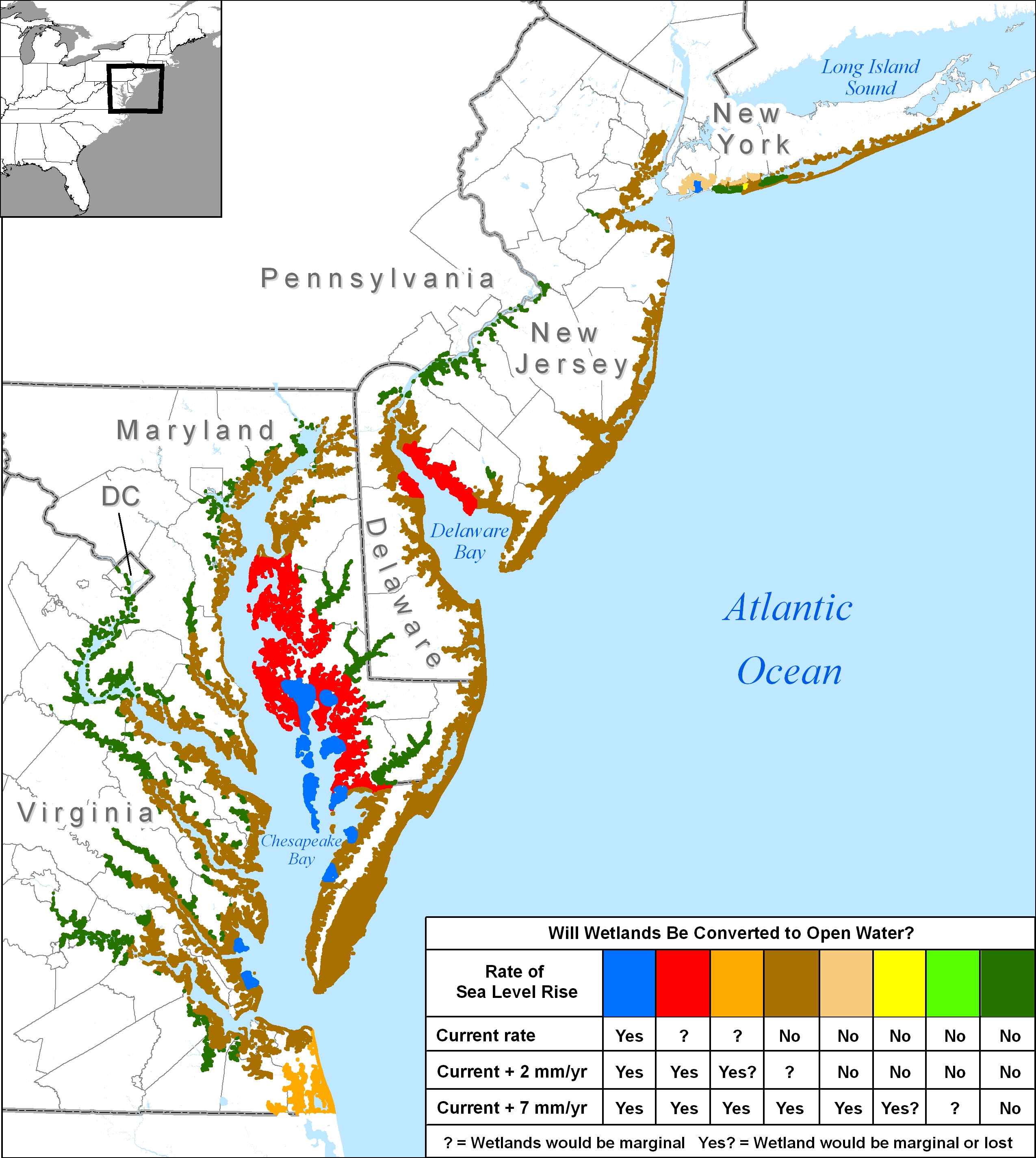
- Maps that show the net loss of tidal wetlands implied by considering coastal elevations and wetland accretion together
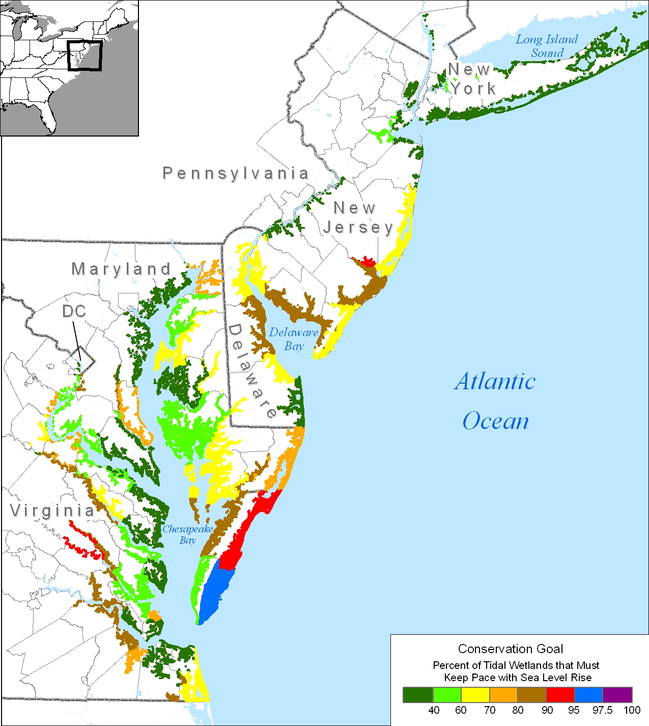
- A map that shows the percentage of tidal wetlands that must keep pace with rising sea level to achieve no net loss
Edited by James G. Titus and Elizabeth M. Strange. 2008. Washington, D.C.: U.S. Environmental Protection Agency. EPA 430-R-07-004.
Tidal wetlands are at sea level, so people have long known that they are potentially vulnerable to sea level rise. Yet for the last few thousand years, the surfaces of most tidal wetlands have risen at about the same rate as the sea was rising. Will wetlands be able to keep pace with the more rapid rate expected in the future?
Past assessments of sea level rise have usually not analyzed that question. Instead they tended to pick assumed vertical accretion rates, and then calculate the consequences. Eventually, scientists will model wetland accretion and test the models against actual experience, but that is not yet possible on a nationwide basis. So EPA convened an expert panel of people who are familiar with the limited data and modeling of wetland accretion, to provide a geographically explicit assessment of vertical wetland accretion.
Section 2.1 (by Reed et al.) explains what the expert panel thinks about tidal wetlands in the mid-Atlantic from the south shore of Long Island to Virginia Beach. Section 2.2, (Titus, Jones, and Streeter) creates a set of maps to summarize the results of the Reed et al. analysis. (The complete set of maps appears in Section 2.1 instead of 2.2 to facilitate the discussion of the various mid-Atlantic subregions.)
Chapter 2: Wetland Accretion in the Mid-Atlantic
Site-Specific Scenarios for Wetlands Accretion in the Mid-Atlantic Region (PDF) (41 pp., 4,301 KB) by D. J. Reed, D. A. Bishara, D. R. Cahoon, J. Donnelly, M. Kearney, A. S. Kolker, L. L. Leonard, R. A. Orson, J. C. Stevenson – An expert panel assessment of how Mid-Atlantic coastal wetlands would respond to changes associated with three sea level rise scenarios.
Maps that Depict Site-Specific Scenarios for Wetland Accretion in the Mid-Atlantic Region (PDF) (12 pp., 1,013 KB) by J.G. Titus, R. Jones, R. Streeter – Maps and a data set depicting a set of site-specific assumptions for wetland vertical accretion developed by a panel of wetland scientists. Summary wetland accretion map (JPG 2.2 MB)