- New Report about Coastal Land Use
- Sea Level Rise Planning Maps
- Elevation Maps
- When the North Pole Melts
Greenhouse Effect, Sea Level Rise, and Land Use
Greenhouse Effect, Sea Level Rise, and Land Use (PDF, 16 pp., 1.8 MB, ) , by James G. Titus, was originally published in Land Use Policy, April 1990, Vol 7: issue 2, pp:138-53. You may view the article below in its entirety or download it in pdf format. For additional reports focused on the implications of rising sea level, go to the Climate Change Site's Sea Level Rise Reports section.
The global warming from the greenhouse effect could raise sea level one meter about one meter in the next century and several meters in the next few hundred years by expanding ocean water, melting mountain glaciers, and causing ice sheets to melt or slide into the oceans. Such a rise would inundate deltas, coral atoll islands, and other coastal lowlands, erode beaches, exacerbate coastal flooding, and threaten water quality in estuaries and aquifers.
Because the worst effects are well into the future, engineering responses to sea level rise will probably be unnecessary for several decades; these structures can be erected over the course of a decade or so. However, because current land use policies can determine whether an area will be developed one hundred years hence, officials should begin today to consider options for averting adverse consequences of sea level rise. The most important decision will generally be determining which areas should be protected with dikes and which should be allowed to flood.
Since the beginning of recorded history, sea level has risen so slowly that for most practical purposes, it has been constant. As a result, people and other species have developed coastal areas much more extensively than would have been possible ten thousand years ago, when sea level was rising more rapidly. Whether one is discussing coral atolls, river deltas, barrier islands, or ocean beaches, life is in a delicate balance with the level of the sea. The projected global warming, however, could disrupt that balance by raising sea level a meter in the next century and perhaps several meters in the next two hundred years.
This article examines the consequences of such a rise. After briefly summarizing the impacts of global warming on sea level, we describe the physical effects of sea level rise and their interaction with current activities, and suggest possible implications for land use policies. We hope that this article helps to motivate the process by which land use policies in developing coastal nations help these nations to prepare to live with a rising sea on a warmer planet.
Past and Future Sea Level Rise
Ocean levels have always fluctuated with changes in global temperatures. During ice ages when the earth was 5°C colder than today, much of the ocean`s water was frozen in glaciers and sea level was often more than 100 meters below its current level. (Donn et al. 1962; Kennett 1982; Oldale 1985). Conversely, during the last interglacial period (120,000 years ago) when the average temperature was 1-2°C warmer than today, sea level was about 6 meters higher than today (Mercer 1968).
When considering shorter periods of time, worldwide sea level rise must be distinguished from relative sea level rise. Although global warming would alter worldwide sea level, the rate of sea level rise relative to a particular coast has more practical importance and is all that monitoring stations can measure. Because most coasts are sinking (although a few are rising), relative sea level rise varies from more than one meter per century in some areas with high rates of groundwater or mineral extraction, to a drop in extreme northern latitudes. Global sea level trends have generally been estimated by combining trends at tidal stations around the world. Studies combining these measurements suggest that during the last century, worldwide sea level has risen 10 to 25 centimeters (Fairbridge and Krebs 1962; Barnett 1984; Peltier and Tushingham 1989).
Future global warming could raise sea level by expanding ocean water, melting mountain glaciers, and eventually, causing polar ice sheets in Greenland and Antarctica to melt or slide into the oceans. Hughes (1983) and Bentley (1983) suggested that over a period of 200-500 years, it might be possible for global warming to induce a complete disintegration of the West Antarctic ice sheet, which would raise sea level about 6 meters. Most recent assessments, however, have focussed on the rise that could occur in the next century. As Figure 1 shows, the estimates are generally between 50 and 200 centimeters, with recent estimates being at the low end of the range.
All assessments of future sea level rise have emphasized that much of the data necessary for accurate estimates is unavailable. As a result, studies of the possible impacts generally have used a range of scenarios. Nevertheless, for convenience of exposition, it is often necessary to refer to only a single estimate. For illustrative purposes, we follow the convention of referring to a one meter rise in sea level.
Physical Effects of Sea Level Rise
We now examine the impact of sea level rise assuming that society's impact on the coastal environment does not change. We first summarize the most important processes, then discuss a few examples of the interaction of these physical impacts with human activities.
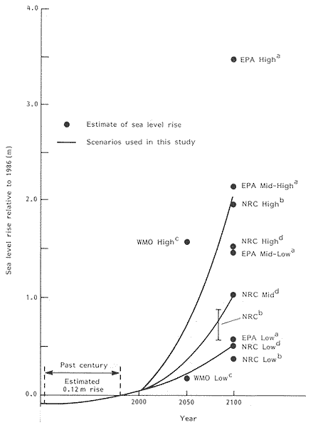 [D]
[D]Figure 1. Estimates of future sea level rise.
Sources: (a) "Environmental Protection Agency, reported in JS Hoffman, D Keyes and JG Titus, Projection Future Sea Level Rise, US GPO, 1983. (b) Glacial volume estimate of National Research Council, reported in MF Meier et al, Glaciers, Ice Sheets, and Sea Level, National Academy Press, 1985, augmented with thermal expansion estimates of the NRC, reported in R Revelle, 'Probable future changes in sea level resulting from increased atmospheric carbon dioxide,' in Changing Climate, NAP, 1983. (c) WMO International Assessment of the Role of Carbon Dioxide and Other Greenhouse Gases in Climate Variations and Associated Impacts, WMO, 1985. (d) NRC, Responding to Changes in Sea Level: Engineering Implications, NAP, 1987.
Processes
A rise in sea level would (1) inundate wetlands and lowlands, (2) erode shorelines, (3) exacerbate coastal flooding, (4) increase the salinity of estuaries and aquifers and otherwise impair water quality, (5) alter tidal ranges in rivers and bays, (6) change the locations where rivers deposit sediment (7), increase the heights of waves, and (8) decrease the amount of light reaching the bottoms. Previous assessments have mostly focused on the first four factors. (e.g. Barth and Titus 1984; Dean et al. 1987).
Inundation. This most obvious impact of sea level rise, refers both to the conversion of dryland to wetland and the conversion of wetlands to open water. Consider a bay with a tide range of one meter and a parcel of dryland that is currently 75 centimeters above sea level, that is, 25 centimeters above high water. If the sea rose 25 centimeters overnight, the land would be flooded at high tide and hence convert to wetland, while a 125 cm rise would convert it to open water.
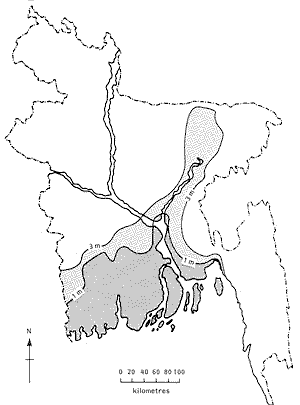
Nature requires coastal wetlands and the dryland found on coral atolls, barrier islands, river deltas to be just above sea level. If sea level rises slowly, as it has for the last several thousand years, these lands can keep pace with the sea: Wetlands collect sediment and produce peat that enable them to stay just above sea level; atoll islands are sustained by sand produced by the coral reefs; barrier islands migrate landward; and deltas are built up by the sediment washed down major rivers. If sea level rise accelerates, however, at least some of these lands will be lost. A one meter rise in sea level would inundate 17 percent of Bangladesh (Ali and Huq 1989; See Figure 2), and a two meter rise would inundate the capital and over one-half the populated islands of the atoll Republic of Maldives. Although the land within a few meters of sea level accounts for a relatively small fraction of the area of most nations, populations are often concentrated in the low areas due to the fertility of coastal lowlands, the historic reliance on water transportation, and more recently, the popularity of living by the sea. Shanghai and Lagos—the largest cities of China and Nigeria—are less than two meters above sea level, as is 20 percent of the population and farmland of Egypt (Broadus et al. 1986).
Coastal plains in general would be less vulnerable than atolls, deltas, and barrier islands, because they typically range in elevation from zero to 70 meters above sea level. Nevertheless, because they account for much more land and do not keep pace with sea level, they would probably account for the majority of dryland lost to inundation, particularly for a large rise in sea level. A recent study of the United States illustrates the situation: If sea level rises 50 cm, the Mississippi Delta alone would account for 35 percent of the nation's lost dryland; but because a 50 cm rise (along with current subsidence) would inundate most it, the delta would account for only 10 percent of U.S. dryland lost if sea level rises 2 meters (U.S. EPA 1989).
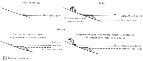
Unlike most dry land, all coastal wetlands can keep pace with a slow rate of sea level rise. As Figure 3 shows, this ability has enabled the area of wetlands to increase over the last several thousand years. However, most authors have concluded that wetlands could not keep pace with a significant acceleration in sea level rise (Kearney and Stevenson 1985), and thus, that the area of wetlands converted to open water will be much greater than the area of dryland converted to wetlands (Titus et al. 1984; Park et al. 1986; Armentano et al. 1988). Moreover, in areas where dikes protect farmland or structures, all the wetlands could be lost (Titus 1986; 1988). Because they are found below the annual high tide, the most vulnerable wetland would tend to those in areas with low tidal ranges.
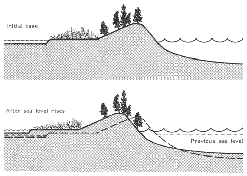
Erosion.In many areas, the total shoreline retreat from a one meter rise would be much greater than suggested by the amount of land below the one meter contour on a map, because shores would also erode. While acknowledging that erosion is also caused by many other factors, Bruun (1962) showed that as sea level rises, the upper part of the beach is eroded and deposited just offshore in a fashion that restores the shape of the beach profile with respect to sea level, as shown in Figure 4; the "Bruun Rule" implies that a one meter rise would generally cause shores to erode 50 to 200 meters along sandy beaches, even if the visible portion of the beach is fairly steep. On coastal barrier islands, wave erosion may transport sand in a landward as well as a seaward direction, a process commonly known as "overwash" By gradually transporting it landward, overwash can enable a barrier island to rise with sea level, in a fashion similar to rolling up a rug, as shown in Figure 5. Wetlands and other muddy coasts would be even more vulnerable to erosion; unlike sand, muddy sediments can be carried great distances before settling out and the peat that comprises part of wetland coasts can oxidize into carbon dioxide, methane, and water (Reed 1988).
The practical importance of distinguishing erosion from inundation varies (Park et al. 1989). Along the very low deltaic coasts, erosion would merely reclaim land a few decades before it was inundated anyway. On barrier islands and sandy cliffed coasts, however, where a one meter rise would only inundate 5-20 meters of beach, erosion would account for the majority of land lost.
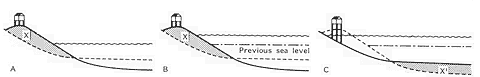
Figure 4. The Bruun Rule.
Notes: (A) Initial condition. (B) Immediate inundation when sea level rises. (C) Subsequent erosion due to sea level rise. A rise in sea level immediately results in shoreline retreat due to inundation, shown in first two examples. However, a 1 m rise in sea level implies that the offshore bottom must also rise 1 m. The sand required to raise the bottom (X') can be supplied by beach nourishment. Otherwise waves will erode the necessary sand (X) from the upper part of the beach as shown in (C). Source: Titus, 1986.
Flooding. Sea level rise could increase the risk of flooding in four ways: (1) There would be a higher base upon which storm surges would build; if sea level rises one meter, an area flooded with 50 cm of water every 20 years would now be flooded with 150 cm every 20 years; surges would also penetrate farther inland (Kana et al. 1984). (2) Beaches and sand dunes currently protect many areas from direct wave attack; by removing these protective barriers, erosion from sea level rise would leave some areas along ocean coasts more vulnerable. (3) mangroves and marshes slow the inland penetration of floodwater by increasing the friction of estuaries and by blocking the waves; losses of wetlands would thus increase coastal flooding (Louisiana Wetland Protection Panel 1988). Finally, (4) sea level rise could also increase flooding from rainstorms and river surges due to decreased drainage (Titus et al. 1987). The higher base for storm surges would be particularly important in areas where hurricanes are frequent, such as islands in the Caribbean Sea, the Southeastern United States, and the Indian subcontinent; had flood defenses not already been erected, London and the Netherlands would also be at risk due to winter storms. By contrast, because storm surges there are rarely more than 50 centimeters, flood damages would not be a major problem for the Maldives (though the absence of high ground for evacuation would justify treating the risk seriously). Erosion would be particularly important on U.S. barrier islands, many of which have houses within 30 meters of the shore at high tide. Because mangroves provide the major protection against flooding for many countries too poor to erect flood defenses, wetland loss could be a major problem there. Reduced drainage would be a chief concern in coastal areas frequently flooded by river surges—particularly deltas—as well as other flat areas.
Floods in Bangladesh would be worse for all of these reasons. In 1971, the storm surge from a cyclone killed three hundred thousand people. Much of the country is flooded by surges in both the Ganges and Brahmaputra rivers; when the surges coincided in 1987, about one third of the country was under water. Although the government has found it difficult to prevent people from cutting them down, mangroves still provide important flood protection buffers. Should the mangroves die, the outer islands erode, natural drainage decline, and storm surges rise a meter higher than today, much of the land not lost to inundation will still experience consequences of sea level rise.
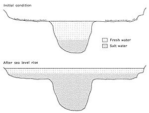
Saltwater Intrusion.Sea level rise would generally enable saltwater to advance inland in both aquifers and estuaries. In estuaries, the gradual flow of freshwater toward the oceans is the only factor preventing the estuary from having the same salinity as the ocean. A rise in sea level would increase salinity in open bays because the increased the cross-sectional area would slow the average speed at which freshwater flows to the ocean. (See Figure 6.)
 [D]
[D]Figure 6. Increasing bay salinity due to sea level rise.
Note: For clarity the diagram assumes that the fresh water has not yet mixed with the salt water. Sea level rise increases the cross-sectional area of the estuary. However, assuming a constant flow of fresh water into the estuary, the cross-sectional area of the freshwater layer must remain constant. Therefore salt water accounts for an increased fraction of total water. When the layers mix the result will be a higher average salinity.
The impact of sea level rise on groundwater salinity could make some areas uninhabitable even before they were actually inundated, particularly those that rely on unconfined aquifers just above sea level. Generally, these aquifers have a freshwater "lens" floating on top of the heavier saltwater. According to the Ghyben-Herzberg (Herzberg 1961) principle, if the top of the aquifer is one meter above sea level, the interface between fresh and saltwater is forty meters below sea level. If sea level rises one meter, aquifers would usually rise one meter as well (Figure 7a-b). In areas where there freshwater is plentiful, this situation would pose little problem.

Note: The freshwater table extends below sea level 40 cm for every 1 cm by which it extends above sea level. (A) For islands with substantial elevation a 1 m rise in sea level simply shifts the entire water table up 1 m, and the only problem is that a few wells will have to be replaced with shallower wells (B). However, for very low islands the water table cannot rise due to runoff, evaporation and transpiration. A rise in sea level would thus narrow the water table by 40 cm for every 1 cm that the sea level rises (C), effectively eliminating groundwater supplies for the lowest islands.
In many areas, however, freshwater supplies are not so plentiful. Droughts and wells can deplete the lens to a total width of a meter or less. Thus, wells that are currently able to draw freshwater during a drought would be too deep if sea level rose one meter. Fortunately, in areas with several meters of elevation, there would still be as much freshwater; people would merely have to drill new wells. (Figure 7b). In the lowest-lying areas, however, the actual amount of freshwater under the ground would decline; the Ghyben-Herzberg principal implies that the top of the freshwater lens does not rise, the bottom of the lens will rise forty times as much as the sea (Figure 7b-7c).
Consider the island of Tuladoo (Republic of Maldives), which is entirely less than 50 centimeters above high tide. Even when the ground is entirely saturated, the lens can extend no more than 50 centimeters above sea level. But the permeable coral material of the island allows much of this water to drain fairly rapidly after storms; and evaporation and transpiration further lowers the water table during the typical dry season. As a result, the freshwater lens is so small that people must obtain water by digging a hole, withdrawing a liter or so of water, and refilling the hole, perhaps coming back the next day. A one meter rise in sea level would leave islands in about a dozen atoll nations with this situation. Even though sea level might have to rise a meter of more to drown an island, a rise as little as 30 cm could eliminate its primary water supply.
By deepening shallow bodies of water, sea level rise could cause them to stagnate. Fish ponds in Malaysia, the Philippines, and China have been designed so that the tides provide sufficient mixing; deeper ponds, however, would require more flushing. Stagnation could also be a health problem in urban areas.
Secondary Impacts. A number of other impacts of sea level rise could be important, such as changes in tidal ranges, sedimentation, and less light reaching water bottoms.
Sea level rise could change tidal ranges by (1) removing barriers to tidal currents and (2) changing the resonance frequencies of tidal basins. Scott and Greenburg (1983) note that the one meter rise in sea level over the last few centuries has altered the resonance frequency of the Bay enough to increase the tidal range by half; and tidal tidal ranges also appears to be increasing along the North Sea coast (Bruun 1986). In some areas, however, tidal ranges may decrease. Changes in tides could alter all of the basic processes discussed so far. A greater tidal range would increase the inundation of dry land, while increasing (or limiting the loss) of intertidal wetlands. Greater tidal currents would tend to form larger ebb tidal deltas, providing a sink for sand washing along the shore and thereby causing additional erosion. Some of the bathymetric changes that might amplify tides would have the same impact on storm surges. Finally, higher tidal ranges would further increase the salinity in estuaries due to increased tidal mixing.
Under natural conditions, most of the sediment washing down rivers is deposited in the estuary due to settling and flocculation. Settling occurs downstream from the head-of-tide because the slowly-moving water characterized by estuaries can not carry as much sediment as a flowing river. Flocculation is a process by which salty water induces easily-entrained fine- grained sediment to coalesce into larger globs which settle out. A rise in sea level would cause both of these processes to migrate upstream, and thereby assist the ability of wetlands in the upper parts of estuaries to keep pace with sea level, while hindering their ability in the lower parts.
A rise in sea level would also increase the size of waves. In shallow areas, the depth of the water itself limits the size of waves, which could be the most important impact of sea level rise along shallow (e.g. less than 30 cm at low tide) tidal embayments with steep, muddy shores. The steep slopes imply that inundation would not be a problem. However, with water depths one meter deeper, waves could form that were large enough to significantly erode the muddy shores.
Bigger waves could also increase the vulnerability of lands protected by coral reefs. In many areas, these reefs protect mangrove swamps or sandy islands from the direct attach by ocean waves; but deeper water would reduce the reef`s ability to act as a breakwater. The extent to which this will happen would depend on the ability of the coral to keep pace with sea level rise. The vulnerability of reefs would be further threatened if reef growth slows. Corals in clear water can grow 10 meters below the surface; by limiting the ability of light to reach the bottom, deeper water would reduce the productivity of coarl (as well as other submerged plant species). Because reefs supply the sand necessary to keep the islands from being eroded and inundated, any limitation of coral productivity could increase the risk that these islands will be eroded or inundated. (Unfortunately, current human activities appear to be threatening coral growth far more than the expected impact due to sea level rise.)
Other Impacts of Global Warming.One must consider the implications of sea level rise in the context of other impacts of global warming, which could alter all of the impacts except inundation. Warmer temperatures could convert marshes to mangroves. If hurricanes or storms become more severe (Emmanual 1988), flooding and erosion will be worse. More droughts would exacerbate salinity and other water quality problems; while if droughts become less frequent, most salinity problems associated with sea level rise might be completely offset. Low islands, however, are an importance exception; if an island with a few meters elevation comes to resemble Tulado in the Maldives, wells will be of little use during the dry season.
Interaction with Human Activities
The impacts of sea level rise can not be fully understood without some discussion of human activities in the coastal zone, they ways humanity has already disrupted natural coastal environments--partly in response to historic sea level rise-- activities that can be expected if current policies continue.
In this section, we focus primarily on the implications for (1) river deltas, (2) other wetland shorelines, (3) beach resorts, (4) coastal cities, and (5) water management.
River Deltas.Most of the basic processes described above would manifest themselves in river deltas. Because deltaic wetlands and lowlands were created by the deposition of river sediments, these lands are generally within a few meters of sea level and hence vulnerable to inundation, erosion, and flooding. During droughts, saltwater intrusion is already a problem in many of these areas. Nevertheless, under natural conditions the sediment washing down the river could enable at least a significant fraction of the typical delta to keep pace with sea level rise.
Human activities in many deltas, however, have disabled the natural ability of deltas to create land. Over the last few thousand years the Chinese—and over the last few hundred years the Dutch—have erected sea dikes and river levees to prevent flooding from storm and river surges. As a result, the annual floods no longer overflow the river banks, and as sea level rises, it has left the adjacent land below sea water level, necessitating more coastal defense to prevent the land from being inundated.
Over the last century, the United States has sealed off Mississippi River distributaries, forcing the flow of water through a few main channels, to prevent sedimentation in shipping lanes. More recently, river levees have also been constructed. Unlike the Chinese and Dutch deltas, however, the Mississippi Delta is not encircled with dikes; as sea level rises and the deltaic mud settle, Louisiana is losing 100 square miles of land per year (Louisiana Wetland Protection Panel 1988). In Egypt, the Aswan Dam prevents the Nile River from overflowing its banks, and its delta is now beginning to erode as well (Broadus et al. 1986). Similarly, a major dam on the Niger River is causing the coast of Nigeria to erode 10-40 meters per year (Ibe and Awisika 1989).
The natural land building processes in some major deltas are still allowed to operate. Most notable is Bangladesh, located in the delta of the Ganges and Brahmaputra Rivers. About 20 percent of the nation is less than one meter above sea level, and close to one third of the nation is regularly flooded by annual river surges. People in agricultural areas are generally accustomed to the flooding, which in addition to depositing sediment provides farmland with important nutrients. Nevertheless, floods have disrupted the capital, and the government is considering river levees to curtail flooding.
Paradoxically, a one meter rise in sea level threatens to permanently inundate deltas that are protected from river flooding, while protected areas may be able to avoid inundation through natural sedimentation. Nevertheless, at least parts of these deltas would probably be inundated. In the case of overcrowded nations such as Bangladesh, the resulting migration away from the coast may exacerbate social tensions and possibly result in massive emigration.
Other Wetland Shorelines. Although human activities would have the greatest impact on deltaic wetlands, they would also influence the ability of other coastal wetlands to survive a rising sea level. Perhaps most importantly, ecosystems could shift landward under natural conditions in most areas. However, in many areas people have already developed the adjacent dryland onto which the ecosystem would have to migrate. If these areas are protected with bulkheads or levees, the wetlands will be squeezed between the rising sea and the flood-protection structure.
Current efforts to control water pollution may have a beneficial impact on wetlands. Healthy marshes and swamps in unpolluted estuaries would be more likely to maintain the vertical accretion rates necessary to keep pace with sea level rise. Furthermore, to prevent estuaries from being polluted by septic tanks, some jurisdictions require houses to be set back 50-100 meters from the wetlands; these setbacks will leave some room for landward migration.
Beach Resorts. Along the ocean coasts of Australia, Brazil, Nigeria, Portugal, the United States, and many other nations, one of the most important impacts of sea level rise would be the threat to recreational beach communities. Particularly in the United States, even a small rise in sea level would erode the exiting recreational beach and leave oceanfront houses standing in the water. In areas where these buildings are protected by seawalls, the entire beach would vanish, removing the primary reason people visit the these communities in the first place.
Moreover, many resorts are located on barrier islands where typical elevations are only one or two meters above sea level. Although natural barrier islands can migrate landward, developed barrier islands do not, both because structures prevent the landward transport of sand and because public works departments tend to bulldoze back onto the beach whatever sand is washed landward. Thus, in addition to oceanside erosion, the low bay sides of these islands would be threatened with inundation.
Coastal Cities.Throughout history, small towns have often been relocated in response to erosion and sea level rise; but cities have generally erected the structures necessary to remain in their current locations. One can reasonably expect that sea level rise will force Dakka, Lagos, Shanghai, and Miami to erect the dikes and pumping systems necessary to avoid inundation. While the primary socioeconomic impact in industrialized nations many be higher taxes, budgets in developing nations may be constrained, forcing them to reduce expenditures on health, education, economic development, and other requirements.
Many cities not immediately threatened with inundation would be flooded. While flood defense is possible, the history of coastal protection suggests that this generally will happen only after a disaster or near-catastrophe demonstrates the need for these projects; one can only hope that the latter occurs first. Case studies in the United States suggest that areas flooded once or twice a century today would be flooded every decade if sea level rises one meter (Barth and Titus 1984).
Environmental Implications
The impacts of sea level rise on ecosystems can be broadly classified into effects of (1) wetland loss, (2) salinity increases, and (3) beach erosion.
Estuarine fisheries depend on coastal wetlands both because they account for a major fraction of primary productivity and because they provide important nurseries due to their ability to protect fish larvae and juveniles from predators. Although primary productivity depends on the total area of wetlands, the productivity of fisheries is widely believed to depend more on the total length of wetland/water interfaces (Browder et al.); unless there is a channel through the wetlands, fish rarely swim more than a few tens of meters into the wetlands.
 [D]
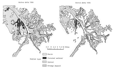
[D]Figure 8. Wetland loss at the mouth of the Mississippi river.
Source: National Coastal Ecosystems Team, US Fish and Wildlife Service.
Although sea level rise would reduce the area of wetlands, at first it would tend to increase the length of the wetland/water interface. Figure 8 illustrates the disintegration of the birdfoot delta of the Mississippi River, where many researchers believe that wetland loss temporarily improved fifth catches. In the long run, however, the decline in wetland area will eventually decrease the total length of the interface, with a roughly proportional impact on estuarine fisheries.
In industrialized nations, the decline of these fisheries would imply higher prices for shrimp, crab, flounder, and other fish that depend on marshes for parts of their life cycles, as well as chicken, which are often fed fishmeal from estuarine species. In some developing nations, however, the decline in these fisheries could threaten subsidence.
Increasing estuarine salinity would also threaten some seafood species, largely because the major predators of these species are unable to tolerate freshwater. Even today, excessive salinity during droughts has been a contributing factor in the decline of oyster harvests in Delaware and Chesapeake Bays (Gunter 1974; Hull and Tortoriello 1979).
Under natural conditions, a rise in sea level would not threaten life along the beach' ecosystems would merely migrate landward. However, the presence of buildings behind the beaches would often prevent landward migration. Along the coast of Florida, for example, beach erosion is already forcing sea turtles in some areas to build their nests under people's houses.
Implications for Land Use Policy
The most fundamental question suggested by sea level rise is whether to retreat or hold back the sea. In the United States, cities and other heavily developed areas will be protected because the value of land and structures is many times the cost of constructing the necessary dikes and pumping systems; lightly developed residential areas, as well as forests and farmland, on the other hand, will probably not be protected because the cost of doing so would be greater than the market value of the land. (Barth and Titus 1984; Dean et al. 1987). The debate in the United States centers on moderately developed lowlands and on areas that are already vulnerable to storms.
Should Lowlands Be Protected
Popular accounts of sea level rise in the United States generally assume that developing nations would not be able to defend their shores, because these nations lack the resources of industrialized countries. We suspect, however, that this line of reasoning is flawed. Most developing nations have emerging middle classes who have bid up the price of real estate in major cities to levels comparable to land values in the west; they would be as willing as Americans to protect their investments.
Two thousand years ago the Chinese were able to erect extensive flood protection along the Yellow and Yangtze rivers; they had the same resources that developing nations have today, human labor. Even poor countries can devote substantial resources to a public works project if it is sufficiently important; it seems reasonable to assume that the protection Dakka, Lagos, Male, and Alexandria is as important to Bangladesh, Nigeria, the Maldives, and Egypt as protecting Miami is to Americans. In Malaysia, Indonesia, and particularly Bangladesh, the need for farmland to support subsistence may even warrant protection of land that would be considered "undeveloped" in the United States.
For nations that depend on fishing for subsistence, protecting "undeveloped" land may not be necessary, and in some cases it may be counterproductive. Although Maldivians harvest coconuts on unpopulated islands, their primary source of subsistence and foreign exchange is fishing, which would not be affected by sea level rise; while maintaining residential and tourist islands would be important, the coconuts would probably not justify protecting small islands.
We have argued previously that property values alone may justify protection of moderately-developed coastal lowlands in the United States, but that when one considers the resulting loss of wetlands as well, the social cost of protection may be greater than the benefits. (Titus et al. 1984; Titus 1986; Titus et al. in press.) This may also be true in developing nations such as Nigeria where many residents rely on estuarine fisheries for subsistence. The fact that allowing wetlands to advance onto agricultural or residential areas might be rational, however, does not guarantee it would happen, particularly if the issue is not addressed until particular properties are facing inundation: Officials would have a very hard time telling people that they will have to abandon their homes for the sake of environmental benefits that would be imperceptible at first, spread over many generations, and accrue more to fishermen from the next village or tourists from another country than to residents of the particular community.
What can be done today to reduce the eventual economic and environmental costs of sea level rise? For undeveloped areas, two obvious options are for governments to purchase land or prohibit development (Titus 1988; Titus 1989). The usefulness of these approaches, however, may be limited; buying all the land less than one meter above sea level could be expensive; and although prohibiting development would not require government expenditures, it would hurt landowners and would be unconstitutional in the United States and nations with similar property rights. Moreover, these policies might merely divert development to areas between one and two meters above sea level and actually worsen the problem if sea level rises more than a meter.
Another possibility would be to allow development in coastal lowlands with the provision that it must be abandoned when the sea rises enough to inundate it. (Titus 1984; 1986; 1989), an approach called "presumed mobility." Unlike land purchases and construction bans, this approach could apply to areas that are already developed. In the United States, Maine (1987) has implemented a regulation that prohibits construction of bulkheads, declares that houses are presumed to be mobile, and requires demolition plans for any large building that would interfere with dunes or wetlands if sea level rises one meter. Presumed mobility does not avoid the need to abandon buildings, but by putting people on notice many decades in advance, the policy will make it harder for property owners to claim that abandoning their homes to the sea is unfair.
A final option that may be particularly useful to developing nations would be channel new economic development to high ground whenever possible. The Maldives ongoing program to establish major cities, for example, should probably focus on islands with elevations greater than two meters. Nevertheless, other considerations such as proximity to existing infrastructure may compel many nations to continue developing areas likely to be inundated by future sea level rise. At the very least, however, these nations should evaluate whether future flood protection costs and the environmental impacts would eventually warrant an abandonment of these areas; if so, they should ensure that the new infrastructure and property rights in these areas are designed to accommodate future sea level rise.
Preventing Flood Disasters
Throughout the world, people have developed barrier islands and river deltas even though they are vulnerable to devastating floods. In the United States, Hurricane Hugo destroyed much of the development on several barrier islands in South Carolina, triggering a debate over a preexisting state law that appears to prohibit many damaged homes from being repaired. Property owners protested that the law is unconstitutional, while environmentalists argued that these islands are fragile environments, and that people are not only risking their own money but the public's as well, since the government pays for much of the flood damages. In most cases, however, property owners have eventually secured the right to rebuild.
Governments in developing nations face the same problems. In Bangladesh, for example, people repeatedly resettle vulnerable islands, even when a storm has recently drowned the previous occupants. In many cases, people are not only placing themselves at risk: the development destroys mangroves and thereby increases flood risks inland. Nevertheless, population pressures have made it difficult for the government to prevent people from settling these areas.
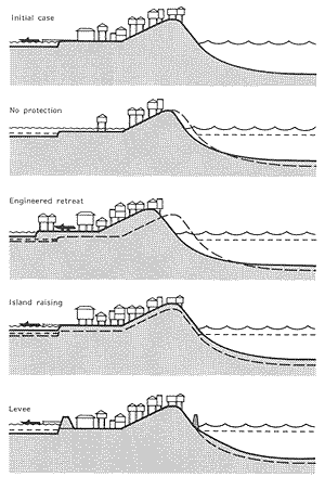
Although sea level rise could increase the risk of flooding on barrier islands, abandonment would not be the only option for well-developed islands. Figure 9 illustrates three other options: dredging sand to raise the island in place, gradually filling in the bay side as the ocean side erodes, and encircling the island with a dike. The feasibility of these options will vary, but at least in the United States, there is a general consensus that most islands will not be abandoned.
Land use policy in river deltas can not be separated from water resources management. Many of the great rivers of the world were dammed for water supply and hydroelectric power, and diked for navigation and flood control, before people realized that doing so would cause the delta to wither away. Future sea level rise suggests that current erosion rates will accelerate. Now that people understand the long-term consequences of harnessing rivers, should some planned projects be dropped, or should they be augmented to include the logistics of protecting deltas with dikes, moving people to higher ground, and finding new occupations for displaced fishermen?
Conclusion
A rise in sea level from the greenhouse effect would inundate many low areas, erode shorelines, exacerbate flooding, and increase water supply problems in coastal areas. Many of the most adverse consequences can be averted by taking timely measures in anticipation of sea level rise. The industrialized nations of the world recognize their obligations. Most important is a worldwide agreement to curtail the emissions of greenhouse gases, which will mitigate all of the problems. But the United Nations, the British Commonwealth, the United States, the Netherlands, and others also have begun pilot efforts to help developing nations contend with whatever impacts eventually occur.
Developing nations, however, must decide for themselves how they ultimately intend to respond to a rise in sea level, and make at least some tentative decisions fairly soon. Donor nations can design and build a dike, but they should not be asked to decide whether protecting buildings or the environment is more important.
References
Ali, S.I. and S. Huq. 1989. "International Sea Level Rise: National Assessment of Effects and Possible Response for Bangladesh." College Park: University of Maryland Center for Global Change.
Armentano, T.V., R.A. Park, and C.L. Cloonan. 1988. "Impacts on Coastal Wetlands Throughout the United States." In. Titus, J.G. (ed) Greenhouse Effect, Sea Level Rise, and Coastal Wetlands. Washington, D.C.: Environmental Protection Agency.
Barnett, T.P. 1984. "The Estimation of "Global" Sea Level Change: A Problem of Uniqueness." Journal of Geophysical Research 89(C5):7980-7988.
Barth, M.C. and J.G. Titus (eds). 1984. Greenhouse Effect and Sea Level Rise: A Challenge for This Generation. New York: Van Nostrand Reinhold.
Broadus, J.M., J.D. Milliman, S.F. Edwards, D.G. Aubrey, and F. Gable. 1986. "Rising Sea Level and Damming of Rivers: Possible Effects in Egypt and Bangladesh." In Titus, J.G. (ed) Effects of Changes in Stratospheric Ozone and Global Climate. Washington, D.C.: Environmental Protection Agency and United Nations Environment Program.
Browder, J.A., H.A. Bartley, and K.S. Davis. 1985. "A Probabilistic Model of the Relationship Between Marshland-Water Interface and Marsh Disintegration." Ecological Modelling 29:245-260.
Bruun, P. 1962. "Sea Level Rise as a Cause if Shore Erosion." Journal of Waterways and Harbors Division (ASCE) 1:116-130.
Dean, R.G. et al. 1987. Responding to Changes in Sea Level. National Academy Press: Washington, D.C.
Environmental Protection Agency (U.S.) 1989. Potential Impacts of Global Climate Change on the United States Washington, D.C.: Government Printing Office.
Emmanuel, K.A. 1988. "The Dependence of Hurricane Intensity on Climate." Nature 326:483-85.
Fairbridge, R.W., and W.S. Krebs, Jr. 1962. "Sea Level and the Southern Oscillation." Geophysical Journal 6:532-545.
Fuhrboter, A. and J. Jensen. 1985. "Longterm Changes of Tidal Regime in the German Bight." In O.T. Magoon et al. (eds) Coastal Zone '85. New York: American Society of Civil Engineers.
Gornitz, V., S. Lebedeff, and J. Hansen. 1982. "Global Sea Level Trend in the Past Century." Science 215:1611-14.
Herzberg, A. 1961. "Die Wasserverversorgung Einiger Nordseebader, Munich." Journal Gasbeleuchtung Wasserversorgung 44:815-819, 842-844.
Hoffman, J.S., D. Keyes, and J. G. Titus. 1983. Projecting Future Sea Level Rise Washington, D.C.: Government Printing Office.
Hoffman, J.S., J. Wells, and J.G. Titus. 1986. "Future Global Warming and Sea Level Rise." In Sigbjarnarson, G. (ed) Iceland Coastal and River Symposium Reykjavik: National Energy Authority.
Hull, C.H.J. and J.G. Titus (eds). 1986. Greenhouse Effect, Sea Level Rise, and Salinity in the Delaware Estuary.Washington, D.C.: Environmental Protection Agency and Delaware River Basin Commission.
Hull, C.H.J. and R.C. Tortoriello. 1979. "Sea Level Trend and Salinity in the Delaware Estuary." Staff Report. West Trenton, N.J.: Delaware River Basin Commission.
Ibe, A.C. and L.F. Awosika. 1989. "National Assessment and Effects of Sea Level Rise on the Nigerian Coastal Zone." College Park: University of Maryland Center for Global Change.
Kana, T.W., J Michel, M.O. Hayes, and J.R. Jensen. 1984. "The Physical Impact of Sea Level Rise in the Area of Charleston, South Carolina." In: Barth and Titus (eds). op. cit
Kana et al. 1986. "Potential Impacts of Sea Level Rise on Wetlands Around Charleston, South Carolina." Washington, D.C.: Environmental Protection Agency.
Kana, T.W., W.C. Eiser, B.J. Baca, and M.L. Williams. 1988. "New Jersey Case Study." In: Titus, J.G. (ed). Greenhouse Effect, Sea Level Rise, and Coastal Wetlands. Washington, D.C.: Environmental Protection Agency.
Kearney, M.S. and J.C. Stevenson. 1985. "Sea Level Rise and Marsh Vertical Accretion Rates in Chesapeake Bay." in O.T. Magoon et al. (eds) Coastal Zone '85. New York: American Scociety of Civil Engineers.
Ku, L.F., D.A. Greenberg, C.J.R. Garrett, and F.W. Dodson. 1985. "Nodal Modulation of the Lunar Semidiurnal Tide in the Bay of Fundy and Gulf of Maine. Science 230:69-71.
Kyper, T. and R. Sorensen. 1985. "Potential Impacts of Selected Sea Level Rise Scenarios on the Beach and Coastal Works at Sea Bright, New Jersey. In Magoon, O.T., et al. (eds). Coastal Zone '85.. New York: American Society of Civil Engineers.
Leatherman, S.P. 1984. "Coastal Geomorphic Responses to Sea Level Rise: Galveston Bay, Texas." In: Barth and Titus (eds). op. cit
Leatherman, S.P. 1979, "Migration of Assateague Island By Inlet and Overwash Processes. Geology 7:104-107.
Louisiana Wetland Protection Panel. 1987. Saving Louisiana's Wetlands: The Need for a Long-Term Plan of Action. Washington, D.C.: Environmental Protection Agency.
Meier, M.F. et al. 1985. Glaciers, Ice Sheets, and Sea Level. Washington, D.C.: National Academy Press.
Park, R.A., T.V. Armentano, and C.L. Cloonan. 1986. "Predicting the Effect of Sea Level Rise on Coastal Wetlands." In Titus, J.G. (ed). 1986. Effects of Changes in Stratospheric Ozone and Global Climate Washington, D.C.: Environmental Protection Agency and United Nations Environment Programme.
Park, R.A., M.S. Treehan, P.W. Mausel, and R.C. Howe. 1989. "The Effects of Sea Level Rise on U.S. Coastal Wetlands." In Environmental Protection Agency. 1989. Potential Effects of Global Climate Change on the United States. Washington, D.C.: Environmental Protection Agency.
Peltier and Tushingham. 1989. "Global Sea Level RIse and the Greenhouse Effect: Might They Be Connected?" Science 244:806.
Reed, D.J. Sediment Dynamics and Deposition in a Retreating Coastal Salt Marsh." Estuarine, Coastal, and Shelf Sciences. 26 (1988) 67-79.
Revelle, R. 1983. "Probable Future Changes in Sea Level Resulting from Increased Atmospheric Carbon Dioxide." in Changing Climate. Washington, D.C.: National Academy Press.
Scott, D.B. and D.A. Greenberg. 1983. "Relative Sea Level Rise and Tidal Developmetn in the Fundy Tidal Systems." Canadian Jurnal of Earth Sciences 20:1554-1564.
Titus, James G. 1984. "Planning for Sea Level Rise Before and After a Coastal Disaster." In: Barth and Titus (eds) op. cit.
Titus, James G. 1986. "Greenhouse Effect, Sea Level RIse, and Coastal Zone Managment." Coastal Management 14:3.
Titus, James G. (ed). 1988. Greenhouse Effect, Sea Level Rise, and Coastal Wetlands. Washington, D.C.: Environmental Protection Agency.
Titus, J.G. 1990. "Greenhouse Effect, Sea Level Rise, and Barrier Islands." Coastal Management 18:1.
Titus, J.G. T. Henderson, and J.M. Teal. 1984. "Sea Level Rise and Wetlands Loss in the United States." National Wetlands Newsletter. 6:4.
Titus, J.G., C.Y. Kuo, M.J. Gibbs, T.B. LaRoche, M.K. Webb, and J.O. Waddell. 1987. "Greenhouse Effect, Sea Level Rise, and Coastal Drainage Systems. Journal of Water Resources Planning and Management 113:2.
Thomas, R.H., "Responses of the Polar Ice Sheets to Climatic Warming." In Meier et al. 1985. op. cit.
Wicker, K., M. DeRouen, D. O'Connor, E. Roberts, and J. Wastson. 1980. Environmental Characterization of Terrebonne Parish: 1955-1978. Baton Rouge: Coastal Environments, Inc.
Wilcoxen, P.J. 1986. Coastal Erosion and Sea Level Rise: Implications for Ocean Beach and San Francisco's Westside Transport Project. Coastal Zone Management Journal 14:3.
Wendland, W.M. 1977. "Tropical Storm Frequencies Related to Sea Surface Temperatures." Journal of Applied Meteorology 16:480.
Williams, P. "The Impacts of Climate Chnage on the Salinity of San Francisco Bay." In: U.S. Environmental Protection Agency, Potential Impacts of Global Climate Change on the United States. Washington, D.C.: Environmental Protection Agency.
Greenhouse Effect, Sea Level Rise, and Land Use (1.8 MB pdf), by James G. Titus, was originally published in Land Use Policy, April 1990, Vol 7: issue 2, pp:138-53.