- Causes of Future Sea Level Rise
- Elevation Maps
- Will we really lose all that land?
- Sea Level Rise Planning Maps
 3.4.2 Transferable Development Rights
3.4.3 State Management of Public Trust Lands to Facilitate Barrier Island Migration
Barrier island towns that wish to relocate inland with the landward migration of the island itself would need cooperation of the state government, which owns the lands beneath the tidal waters. Unlike the typical TDR scheme, the receiving area would be lands that are—at least initially—publicly owned. Here we consider two rolling easement approaches for migrating barrier islands:
- Replacement of land lost on the ocean side with similar parcels of newly created land on the bay side; and
- Transfer of development rights so that the landward migration gradually replaces low-to-moderate-density development on the ocean side with a combination of high-density development and open space on newly created bayside lands.
While rolling easements along an eroding shore would involve restrictions of shore protection or grading, facilitating the landward migration of a barrier island would involve conversion of shallow waters or wetlands into developable dry land. In many states, environmental regulations prevent or discourage the filling of navigable waters.[318] The purpose of those rules was historically to halt the previous practice of converting large portions of back barrier bays into development, not to prevent a gradual landward migration of barrier islands. Nevertheless, existing rules do not have an exception for barrier island migration; so they currently prevent it. The environmental implications of creating new land on the bay side would depend on opportunities to mitigate other environmental stressors,[319] whether the bay is wide or narrow, and whether the bay will also migrate onto the mainland.[320]
The question whether landward migration of barrier islands would be better or worse for the environment than the alternatives is beyond the scope of this report. Instead, we attempt to describe a few ways that such a migration could be organized, so that the desirability of a landward migration can be better evaluated.
Parcel-by-Parcel. Under Roman Law, if “the violence of the stream sweeps away a parcel of your land and carries it down to the land of your neighbor, it clearly remains yours….”[321] Although courts have never extended that principle to the case where a hurricane washes a parcel from the ocean to the bay side of an island, the same framework could apply to barrier islands. Rolling easements could facilitate the landward migration of a barrier island in ways similar to the retreating shores we have already examined—except that they must address the advancing bay shore, as well as the retreating ocean shore. The mechanics of an advancing bay shore would in some ways be the mirror image of the rolling easement along the ocean shore.
To illustrate how rolling easements might facilitate landward migration of a barrier island, we start with a possible approach under standard property law for a newly developed barrier island. Figure 10 shows hypothetical parcels, with solid lines showing proposed subdivision lots and dashed lines showing possible future lots if the island migrates inland. One approach is to structure rolling easements as a possibility of reverter, in which the reversion is based on shoreline erosion, as discussed in section 3.2.2. The chief difference is that, in addition to parcel A reverting from the buyer to the state as the shore erodes, the buyer would also receive a future interest in parcel A1 that vests when parcel A is submerged. To address the eventual loss of lot A1 as well, the interest in A1 could terminate as the shore erodes, and the buyer would also receive a future interest in parcel A2, which (i) would vest after both A and A1 have submerged and (ii) terminate as the shore erodes, and so on. Alternatively, the buyer might receive (i) parcel A in fee simple absolute subject to a shoreline migration conservation easement, which prevents shore protection, (ii) a future interest in parcel A1 that vests when parcel A is submerged, which would also be subject to a shoreline migration easement, and so on. In a state where future interests are no longer feasible, the owner might initially purchase all of the parcels (A, A1, A2, …) in fee simple, with conservation easements that prohibit (i) shore protection along the ocean, (ii) occupancy of more than one parcel, and (iii) filling that makes the island wider than a specified width.
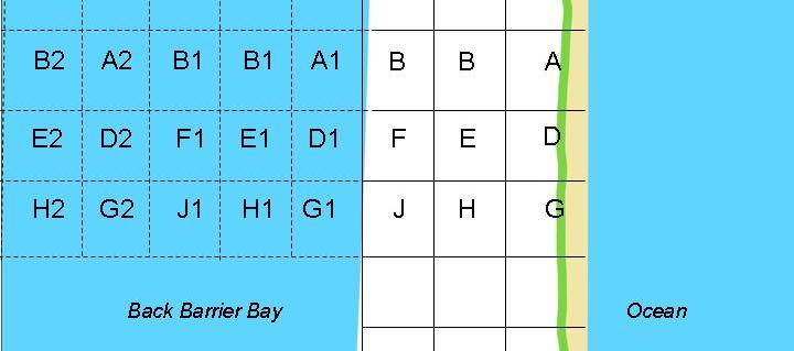 Figure 10. Sketch of Parcel Boundaries for Hypothetical Rolling Easement Arrangement on a Migrating Barrier Island. Under the traditional common law of property, if the state wanted to facilitate landward migration, it could sell the owners of parcel A a future interest in the currently submerged parcel A1 that transfers ownership (for example) when 75% of parcel A is seaward of the dune vegetation line and parcel A has been transferred to the state; and a future interest in parcel A2 that similarly transfers as parcel A1 is eroded and transfers to the state. |
With a newly developed (or redeveloped) barrier island, buyers would have notice that the nature of their homes will change over time. Bayfront home C will eventually lose its water access when lot A1 becomes developed, but once lot B is vacated in favor of lot B1, C will be along the ocean. In existing towns, by contrast, those who inhabit the bay sides of barrier islands have no reason to expect the considerable disruption that could occur from creating developable lots between their homes and the bay. Because these barrier islands were not developed with the expectation of a landward migration, property law (rather than deeds drafted by a developer and state land office) would govern who owns any newly created land.
Most state courts follow the traditional common law rule and treat lands filled by the state as an avulsion, which awards land to the state.[322] But several state courts view it as an artificial accretion, partly because it is unfair for the state to deprive a littoral landowner of her waterfront access.[323]
If the state owns the newly created land, it could sell the land to the highest bidder or transfer parcels to those who lose land on the ocean side, possibly at a reduced cost (see Figure 11). In effect, the rolling easement would provide new land on the bay side to offset land lost on the ocean side. One challenge for this approach would be that the previous bayfront owner would lose the waterfront benefits of her property. While generally harmful to bayfront interests, it would be particularly harmful to marinas, yacht clubs, parks, harbor facilities, and conservation lands[324] that depend on bayfront access. If the land is sold at fair market value, those facilities could buy the new waterfront land and sell some of their old land. But this option might not be affordable to community organizations. Relocating harbors can be costly. Moreover, the new bayfront land that the facilities would have to buy would command a higher price than the formerly bayfront land that they would sell. In effect, the premium associated with waterfront property would shift to the newly created land. The problem of shifting waterfront premiums could be avoided if the state swapped the new bayfront land for what had been bayfront land, and transferred the former bayside land to the displaced oceanside owners.
If the newly created land is owned by the bayfront owner, the loss of bayfront ownership will not be an issue. The bayfront owner could sell the newly created lot to someone else, such as the former oceanfront owner (Figure 11c), possibly retaining an easement for access to the water (Figure 11d), or move her house to the new bayside lot and sell (or rent) the former bayfront lot to someone else (Figure 11e). Without modification, such a policy could leave the bayfront owner in possession of the entire width of the island from ocean to bay once the ocean shore eroded up to today's bayfront parcel. Even if the bayfront owner subdivided the newly created land, the economic effect of barrier island migration would be to award the land to the bayfront owner. The apparent inequity of effectively giving the entire migrating island to the bayfront owners could lead states to condemn the rights to any artificially accreted lands before reclaiming land from the bay.
As an alternative, the bayfront owners could negotiate an arrangement with the state in which the oceanward boundary of the bayfront owner's land becomes ambulatory, so that once a new bayfront lot is created, the bayfront owner takes title to that lot—but yields the pre-existing lot, which would become available to the state, possibly to transfer to the ocean front owner losing her lot to beach erosion. Such an approach would protect the bayfront owner's access—but owners with waterfront views who do not own property immediately along the water might feel they were losing near-access to the bay. Another problem is that this approach would involve repeatedly moving bayfront facilities 50–100 feet bayward every time an oceanfront lot was lost to the ocean and a new bayside lot created.
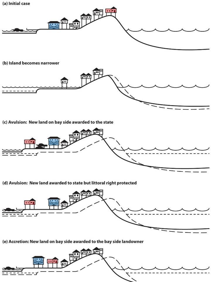 Figure 11. Four Options for the Fates of the Oceanfront and Bayfront Homes on a Developed Barrier Island if Shore Protection along the Ocean Becomes Economically or Environmentally Unacceptable. The initial case (a) shows the cross section of a developed barrier island. If sea level rises, (b) some barrier islands become narrower as the ocean side erodes and the bay side becomes submerged. An alternative is to create a new bayside parcel to replace the parcel lost on the ocean side. In most jurisdictions, state courts would award this newly created lot to the state under the doctrine of avulsion. The state could (c) provide the new lot to the owner of the oceanfront lot. In some states, the original bayfront owner would still have the right to bay access (d), which in this case could mean continuing to have a dock with a boat. Alternatively, the state could award the newly created bayfront lot to the original bayfront owner (e) in return for the formerly bayside lot, which could be provided to the original oceanfront owners. |
Larger-Scale Reclamation. Less frequent but larger-scale land reclamation would allow greater flexibility to achieve community goals. Rather than moving homes piecemeal as small areas of bay are filled, it may be more cost-effective to create an entire city block bayward of existing development, and allow people inhabiting the existing bayside block of land to move their homes bayward to the new block to maintain their pre-existing distance to the bay. In addition to largely preserving existing waterfront access and views, shorefront facilities would only have to be relocated every time a block of land eroded, rather than every time a parcel of land eroded.
Alternatively, larger scale reclamation along with a TDR policy can encourage a more sustainable redevelopment, for example, by replacing existing low-to-moderate-density housing with a combination of high-density development and open space or conservation lands. Figure 12 shows three examples of how transferable development rights could facilitate the landward migration of a developed barrier island. Under natural circumstances, many barrier islands would narrow as they migrated inland. In Figure 12b, the creation of new bayside land is less than half the land lost to oceanside erosion. The new land is thus developed more densely. In this example, the original bayside park's boundaries also migrate landward, but leave less residential land between the park and the ocean than before. Another alternative is to open new conservation-oriented parks on some of the newly created bayside land, and leave the original park's oceanward boundary where it had been (Figure 12c).
A final possibility is to use transferable development rights to return (for example) half of the island to nature. In Figure 12d, new bayside lands are created on the eastern half of the island, but very little new land is created on the western half (and that land is wetlands similar to what might have been created naturally had human activities not disabled the overwash process). All new development takes place on the eastern half of the island. A gradual depopulation takes place on the western half of the island, with no new development. As the shore erodes, eventually there will be no homes along the western end of the island; so that end of the island could be returned to nature. Possibly an inlet will eventually separate the undeveloped west end from the developed east end. Similarly, transferable development rights could facilitate shifting all development on one island to an adjacent island. Such a redevelopment scheme could increase the amount of natural barrier island habitat, reduce the amount of ocean shoreline requiring costly shore protection, and increase the economic feasibility of protecting the island to which the development is transferred.
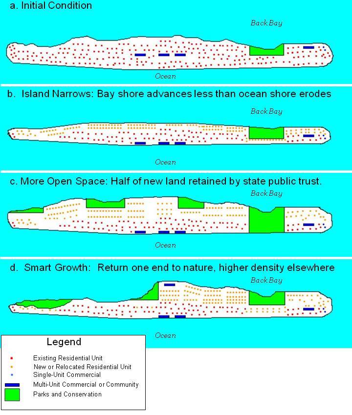 Figure 12. Options for Changing Land Use on a Retreating Barrier Island. The large buildings depicted in blue provide a reference for how far north the island migrates. (a) shows the existing land use pattern. One possibility is (b) increased density and creating less bayside land than the area lost to oceanside erosion, because under natural conditions, most barrier islands would narrow. If the original area is maintained (c), additional parks and conservation land could be created. Finally, (d) one portion of the barrier island could be entirely left to natural processes with no new construction or shore protection, as displaced owners move to the other end, which becomes more densely populated. |
[319] The new
parcels could have living shorelines instead of the bulkheads often found
today
on the bay sides of
barrier islands. Wherever the existing bay side is wetlands or seagrass, such
habitat may also need to be re-created
inland.
[320] If the
mainland shore is protected, then barrier island
migration will narrow and possibly eliminate
the bay. But if the mainland is low-lying and
not protected, then any loss of shallow water habitat on the bay side of the
barrier island will be more than offset by the creation of new
habitat along the retreating mainland shore. See Sax, supra note 65,
at 329 and 357 (quoting Institutes of
Justinian, liber 2, title 1, § 21).
[322] See supra notes 68 to 73 and accompanying text. Some state laws that award the land to the public trust also preserve the original bayfront owner's right to access. See supra note 73
[324] Because
most
conservation areas
on barrier islands extend from the ocean to the bay, this is usually not an
issue. But in a few cases, the ocean side is developed while the bay side is a
conservation area, such as the lands owned by the U.S. Fish and Wildlife Service
in Nags Head and The Nature Conservancy in Kitty Hawk, both of which are in Dare
County, North Carolina. To date, there has been no effort to find new home sites
for lost homes in Nags Head, where development is only a few houses wide. There
has been an effort, however, to ensure that the roadway along the entire length
of the barrier island is maintained as the shore
erodes.
This page contains a section from: James G. Titus, Rolling Easements, U.S. Environmental Protection Agency. EPA-430-R-11-001 (2011). The report was originally published by EPA's Climate Ready Estuary Program in June 2011. The full report (PDF, 176 pp., 7 MB) is also available from the EPA web site.
For additional reports focused on the implications of rising sea level, go to Sea Level Rise Reports.