- Causes of Future Sea Level Rise
- Elevation Maps
- Will we really lose all that land?
- Sea Level Rise Planning Maps
 2.1 Preserve beaches
2.2 Preserve Access along the Shore
Eroding beaches can impair the legal right to access along the shore, whether or not the beach is eliminated. We first summarize existing public rights to access along the shore (Section 2.2.1); then we describe the possible impact of sea level rise (Section 2.2.2) and examine how rolling easements can preserve public access along the beach (Section 2.2.3).
The general right of access to tidal waters and shores is defined by the “Public Trust Doctrine”, which is part of the common law of property in all of the United States. According to the Public Trust Doctrine, navigable waters and the underlying lands were publicly owned at the time of statehood[31] and remain so today[32] unless the state has consciously transferred ownership to someone else.[33] Even if a land deed seems to say that someone’s property extends into the water, the Public Trust Doctrine often overrides that language, and the public still owns the shore.[34]
(Many scholars and a few courts have suggested an expanded Public Trust Doctrine that prevents the government from privatizing submerged land.[35] In this report, “Public Trust Doctrine” refers to the collection of laws governing public and private property rights along the shore, not legal theories about legitimate governmental power.)
Figure 2 illustrates some key terminology used in this report. The wet beach lies between mean high water and mean low water. More precisely, the wet beach is seaward of the line along the beach whose elevation is the same as mean high water, which is sometimes called the “mean high water line”[36] or the “mean high tide line.” The wet beach extends seaward to the comparable mean low tide line, below which the landscape is often called open water because it is covered by water during the typical low tide. Immediately inland of the wet beach is the dry beach. The dry beach extends from the mean high water line inland to the seaward edge of the dune grass or other terrestrial plant life, sometimes called the vegetation line. [37] The dune grass generally extends inland from the point where a storm in the previous year struck with sufficient force to erode the vegetation,[38] which is inland of the high water mark of the average daily tide and well above mean high water.
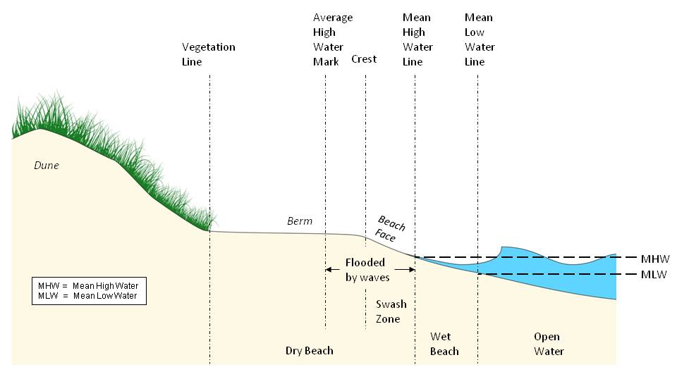
Figure 2. Legal and Geological Zonation along a Beach.
Wet beach is defined as the land between the mean low water line and the mean high water line. Dry
beach is defined as the land between the dune vegetation line and the mean high water line. The term is
a misnomer because along ocean shores, a large part of the dry beach is wet. The swash zone is
generally saturated as waves run up the beach face. During an average high tide, several waves
generally run up over the crest, leaving a water mark on the sand and sometimes debris such as
seaweed at the average high water mark. Unusually high tides or heavy seas can bring waves inland of
the average high water mark, preventing dune vegetation from becoming established seaward of the
vegetation line. Under the public trust doctrine, the public owns the land below the "ordinary high water
mark". in all but a handful of states. Courts in different states have defined "ordinary high water mark"
differently.
|
|
|
|
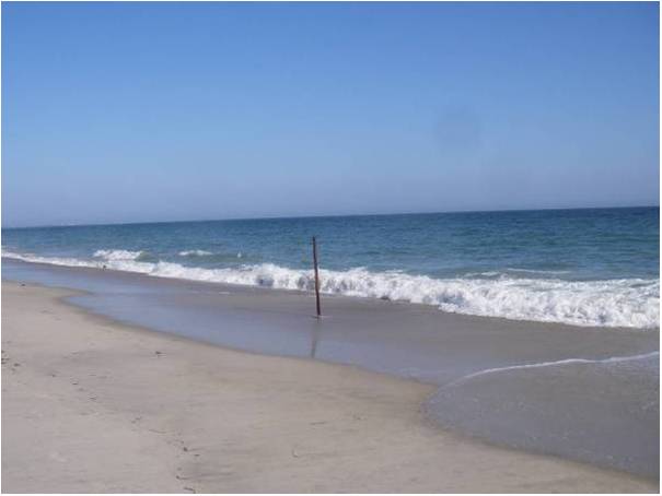
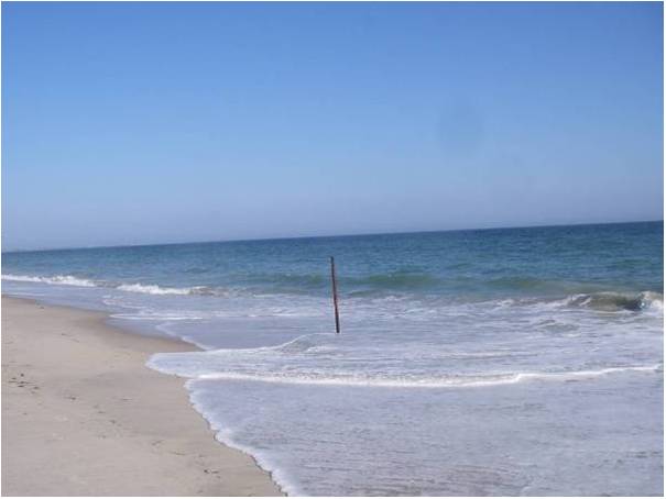
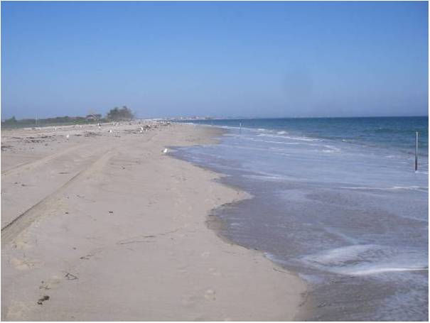
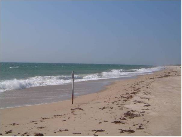
Photos 10 to 13. How wet is the dry beach? The U.S. Fish and Wildlife Service surveys the mean high water line at Trustom Pond National Wildlife Refuge (South Kingstown, Rhode Island) each year, and places posts along the survey line. The dry beach is everything inland of the posts. The top two photos show one of those posts before (top left) and after (top right) a typical wave, at mid-tide on a day with average seas. At high tide, the water would have been almost two feet deeper (September 5, 2008). The lower left photo shows an adjacent post (about a minute earlier), with waves running up the beach face, and gulls feeding along the drift line where waves deposited floating vegetation at the last high tide. (September 5, 2008). The lower right photo shows the same location during average seas when water levels were at approximately the neap low tide level. Even at low tide, the waves are almost reaching into the dry beach. Photo Source: Janet Freedman, Rhode Island Coastal Resources Management Council. |
The term “dry beach” is a misnomer.[39] Along beaches with large waves, such as the Atlantic and Pacific Oceans, wave run-up regularly washes well inland of the mean high water line (see Photos 10 to 13). A person standing on the dry beach a step inland of the mean high water line during the average high tide would regularly experience waves bringing water levels between the shin and the waste. The beach is regularly saturated to the crest of the berm, which is typically a few feet higher and tens of feet inland of the mean high tide line. The highest wave of a given high tide generally leaves a high water mark which can be readily observed by anyone walking along the beach. In this report, we use the term average high water mark[40] to indicate the high water mark left by the average high tide during average seas (i.e. typical wave heights). The portion of the dry beach between the average high water mark and the dune line truly is dry on an average day (assuming no rain).
Box 2 (in Section 2.4) shows the corresponding classes for wetland shores. Mudflats are found between mean low water and mean sea level, low marsh is found between mean sea level and mean high water, and high marsh extends from mean high water to spring high water.[41] Mangroves extend up to spring high water, but zonation between different types depends more on salinity and temperature than the tides.[42] Collectively, the lands between mean high water and mean low water (mudflats, low marsh, and wet beaches) are commonly known as tidelands.
In all but five states, the public owns the land below the “ordinary high water mark,” which state courts have defined differently.[43] The most common definition is the mean high water line. Until the 20th century the term “ordinary high water mark” did not have a specific legal definition,[44] which led people to assume that it referred to something tangible, such as an actual mark or the impact of water on the land’s suitability for specific uses.[45] But in 1935, the U.S. Supreme Court endorsed the approach of calculating the ordinary high water mark based on an elevation survey of the mean high water line. [46] (The case concerned a tract of land originally granted by the federal government along a shore without substantial wave runup). The elevation of mean high water is estimated using tide gauge data over an 18.6 year tidal epoch. Several state courts subsequently endorsed using the mean high tide line for a variety of reasons.[47] Texas uses variations of the mean high tide line[48] as a starting point, but will consider other factors if they regularly cause higher water levels.[49]
Along ocean shores, parts of the privately owned dry beach are regularly flooded, to the extent that wave runup causes the average high water mark to be inland of the mean high tide line. Courts in some states have not yet decided whether the public owns the part of the beach between the mean high tide line and the average high water mark.[50] This distinction is unimportant along estuaries with no waves, because the average high water mark is the mean high tide line.
Some states use neither the average high water mark nor the mean high tide line. In states where the original land grants were made during French, Spanish, or Mexican rule, the public trust boundary is often farther inland, because under the civil law, more of the beach was publicly owned than under English common law.[51] Hawaii and Washington have taken account of the particularly large waves along the Pacific Ocean by defining the ordinary high water mark as the dune vegetation line or the mark of floating debris left by the high tide.[52] In areas where mangroves dominate, the ordinary high water mark can be especially difficult to ascertain and surveyor’s meander lines are sometimes the only practical boundary.[53] In five states, by contrast, original land grants from the King of England provided land down to mean low water, so private landowners own the wet beach and low marsh, as well as the dry beach and high marsh.[54] (See Figure 3.)
Finally,
regardless of the original land grants and the public trust doctrine, the public
has obtained ownership to some dry beaches through government purchase, land
dedication by a developer[55], or beach nourishment projects that created beaches from publicly
owned waters.[56] On the other hand, many state governments have conveyed some bay
bottoms and tidal wetlands to private landowners for residential and commercial
development, especially in Florida.[57] Unless
otherwise stated, this primer assumes that the state has not conveyed tidelands
or other submerged lands to a private party
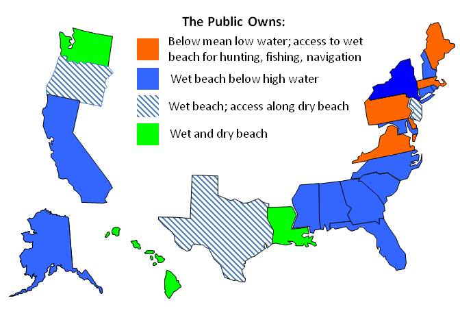 Figure 3 Public ownership and public access to beaches based on the public trust doctrine or other common law doctrines. The public has access along some dry beaches in most states, in addition to the six shown here, where access is universal. |
Ownership, however, is only part of the picture. Along the ocean coasts of New Jersey and Oregon, the public trust doctrine (or the similar doctrine of custom) provides for public access along the privately owned dry beach.[58] In the five states where private property extends to mean low water, the Public Trust Doctrine provides an easement along the land below the ordinary high water mark for hunting, fishing, and navigation.[59] Most of the 20th century cases that defined the boundary of private lands as the mean high water line did not address public access along ocean shores, so it is unclear whether the public has access to the regularly flooded part of the “dry” beach (i.e. between the mean high water line and the average high water mark).[60] Finally, when government agencies transfer ownership of tidelands to private owners, the public still has access along the shore for fishing, hunting, and navigation, unless the state explicitly indicates an intent to extinguish the public trust.[61]
The public also has access along many specific beaches for reasons other than the public trust doctrine. Along most of the Texas Gulf Coast,[62] and parts of other states,[63] the public has obtained an easement to the beach because of longstanding use. Elsewhere, state or local governments have purchased easements for access along the dry beach, or property owners have provided public easements in return for beach nourishment. Federal policy precludes funding for shore protection unless the public has access to the entire dry beach.[64] Figure 3 summarizes the variation of public access and ownership of the beach.
[31] In 1842, the
United States Supreme Court stated that all 13 original states followed the
public trust doctrine. See Martin v. Lessee of Waddell, 41 U.S. (16 Pet.)
366, 410 (1842) (“For when the revolution took place, the people of each state
became themselves sovereign; and in that character hold the absolute right to
all their navigable waters, and the soils under them, for their own common
use.”) Chief Justice Taney pointed out that submerged lands had originally been
“held by the king . . . as the representative of the nation, and in trust for
them.” Id. at 409. New states were granted submerged lands upon
statehood. Pollard v. Hagan, 44 U.S. (3 How.) 212, 229–30 (1845). A century
later, the Supreme Court held that the federal government had retained tidelands
along the ocean coasts of all new states. United States v. California, 332 U.S.
19, 38–41 (1947). Congress overruled this decision with the Submerged Lands Act
of 1953, 43 U.S.C. §§ 1301–1356, which grants the
states the ocean floor out to the three-mile limit, see 43 U.S.C.
§ 1312.
[32] In some cases, the public that
owns the tidelands is a Native American tribe, in
which case the tribe rather than the state
owns those public trust tidelands
today. See, e.g., U.S. v. Milner, 583 F. 3d 1174, 1190 (9th Cir.
2009).
[33]
See generally Richard J. Lazarus, Changing Conceptions of Property and
Sovereignty in Natural Resources: Questioning the Public Trust Doctrine, 71
Iowa L. Rev. 631 (1986) and Carol Rose, The Comedy of the Commons: Custom, Commerce,
and Inherently Public Property, 53 U.
Chi. L. Rev. 711, 715–23
(1986).
[34]See
Martin, 41 U.S.
(16 Pet.) at 410; see also
David C. Slade et al.,
Putting the Public Trust Doctrine to
Work 175 & 180–81 nn.5–10 (1990)
(discussing judicial limitations on the ability of states to convey public trust
lands to private parties); cf. United States v. Denver &
Rio Grande
Ry. Co., 150 U.S. 1, 14 (1893) (“It is . . . the well-settled rule of this court
that public grants are construed strictly against the grantees, but they are not
to be so construed as to defeat the intent of the legislature . . . .”).
[35] See, e.g., Joseph L. Sax, The Public
Trust Doctrine in Natural Resource Law: Effective Judicial Intervention, 68
Mich. L. Rev. 471, 473 (1970) (describing an expanded public
trust doctrine) and James L. Huffman,
Speaking of Inconvenient Truths—A History of the Public Trust Doctrine,
18 Duke Envl. L. & Pol’y F. 1,
4–7, 37–69 (2007) (summarizing legal commentaries advocating an expanded public
trust doctrine and discussing court opinions that adopted that expanded doctrine
or mentioned it while basing their rulings on other
grounds).
[36]
The scientific and legal literature do not mean the same thing by “high water
line”. Scientific papers generally
mean a visually discernible line in the land made by the high water. See e.g. Elizabeth H. Boak & Ian L.
Turner, Shoreline Definition and
Detection: A Review, 21 Journal
of Coastal Research: 690–697
(2005). Court opinions
generally mean an elevation contour.
See infra note 46
and accompanying text.
[37] See e.g. Severance v. Patterson, No. 09-0387 (Tex. 2010) (“The area from mean
low tide to mean high tide is called the "wet beach," because it is under the
tidal waters some time during each day. The area from mean high tide to the
vegetation line is known as the “dry beach.”); City of Long
Branch v Liu, No A-9 (N.J. 2009) (“The mean high water mark, generally,
is the boundary line that divides private ownership of the dry beach and public
ownership of tidally flowed lands”); and Stephanie Reckford, Limiting the Expansion of the Public Trust Doctrine in New
Jersey: A Way to Protect and Preserve the Rights of Private Ownership,
36 Seton Hall L. Rev. 249, 249 n.2
(2005)
(same).
[38] Cf. Orrin H. Pilkey, Jr. and William J. Neal,
editors, Living with the East Florida Shore 25–28 (1984) (explaining that
storms erode the beach and dunes by washing sand offshore, but that after the storm
subsides, fair-weather waves rebuild the beach and dunes). The vegetation line
tracks the inland reach of the most
severe
storm
of the year,
because recently eroded dunes and beaches typically
lack vegetation
until
the next year. Id. at
25.
[39] See e.g. Boak & Turner at 690 (showing that
the divide between wet and dry land is inland of mean high
water).
[40] The
more common terms in the scientific literature are “high water line” and
“wet/dry line.” See e.g. Boak & Turner at 690–697 (finding that the most commonly used
shoreline reference had been the “high water line”, which is sometimes called
“wet/dry line”). But “high
water line” could easily be confused with “mean high water line” or “high tide
line,” which are based on surveyed elevations. See supra note 36
and accompanying text. The term
“wet/dry line” has been criticized as imprecise. Id. at
697.
[41]Maurice
W. Provost, Tidal Datum
Planes Circumscribing Salt Marshes, 26 Bulletin of Marine Science 583
(1976) (explaining that low marsh
extends up to mean high water, while high marsh extends up to unusually high
tides).
[42]
See, e.g., T.J. Huisman, F. Van
Langevelde, & W.F. De Boer, Local positive feedback and the persistence
and recovery of fringe Avicennia marina (Forssk.) vierh. Mangroves 17 Wetlands Ecol. Manage. (2009) 601, 603
(citing W.F. De Boer et al., 428 Hydrobiol 187–196 (2000) and P.J. Hogarth, The Biology of Mangroves.
(1999)).
[43]
See Slade et al, supra note 34,
at 59 & 64 n.8 (listing cases from all 23 tidewater state courts defining
the landward boundary of the public trust).
[44] See, e.g., Frank E Maloney & Richard C
Ausness, The Use and Legal Significance of the Mean High Water Line in
Coastal Boundary Mapping, 53 N.C. L. REV. 186, 204 (1974); and George M
Cole, Tidal Water Boundaries
Symposium on Sovereignty Lands, 20 Stetson Law Review 165, 166
(1990).
[45]
See generally Charles E. Corker, Where Does the Beach Begin, and to What
Extent Is This a Federal Question, 42 Washington Law Review 33 (1966).
[46] Borax
Consolidated, Ltd et al. v. Los Angeles, 296 U.S. 10 (1935). The Court’s
analysis focused on the distinction between neap high tide, mean high tide, and
spring high tide and held that the ordinary high water mark referred to the
average high tide. The opinion did
not address the question whether wave runup causes an actual water mark but simply
asserted “This does not mean, as petitioners contend, [that the ordinary high
water mark is] a physical mark made upon the ground by the waters; it means the
line of high water as determined by the course of the tides,”
id. at 23,
and cited opinions
that distinguished various tide levels. Id, but did not address wave runup or actual
water marks. The case involved
Mormon Island within Los Angeles Harbor, id. at 12, where wave runup is not
significant. Thus the holding did
not necessarily create a rule of law that federal grants extend to the mean high
water line when there is significant
wave runup. But a few federal
courts have assumed that Borax created such
a rule along the ocean coast. See e.g., U.S.
v. Washington, 294 F. 2d 830,
834
(9th
Cir.
1961)
(“the high-water
mark means the line of high water as determined by the course of the tides, not
as determined by physical markings made upon the ground by the water. The latter
method of making this determination, which was followed by the district court,
is appropriate only in the case of streams and other nontidal waters which have
no absolute ascertainable level because of variations of flow from a multitude
of causes.”) and Sotomura v. County of Hawaii, 460 F. Supp.
473, 478–479 (D. Haw. 1978) (relying on Borax and U.S. v. Washington). Several courts have stated in passing
that Borax implies that federal
grants extend to mean high water along an ocean shore, while deciding cases that
do not depend on whether it does or not. See e.g. Hay v. Bruno, 344 F. Supp. 286,
287
(D. Or.
1972);
California ex rel. State Lands Comm'n
v. United States, 457 US 273, 289 (1982) (J. Rehnquist, concurring);
U.S.
v. Alaska, 521 US 1,
23–25 (1997); and Udall v.
Oelschlaeger, 389 F. 2d 974, 975–976 (D.C. Cir.
1968).
[47] Some
courts have
defined “ordinary high water
mark” as the mean high tide
line without providing a reason or indicating a
recognition that
the mean high tide
line is not a water mark along ocean shores. E.g. O'Neill v. State Hwy. Dept., 50
N.J. 307, 323–324 (1967); Purdie v. Attorney General, 143
N.H. 661, 664–667 (1999); and State v. Fain, 259 S.E. 2d 606 (S.C. 1979). Some adopt the rule because
(ignoring shore erosion) the mean high tide line
can be determined more precisely
than
the visual observation of a water mark. State v. Ibbison, 448 A.2d 728,
732 (R.I. 1982) (public access case) “The mean-high-tide line represents the
point that can be determined scientifically with the greatest certainty”. Ibbison at 732. Another common reason has
been that the
litigants had
asked the court to choose between the mean high tide line
and
either a watermark
or vegetation mark that was created by spring high tide, or the annual
storm tide that generally defines the dune vegetation line; neither litigant
proposed the line of ordinary wave runup as the ordinary
high water mark. E.g., Purdie at 664–665 and Carolina Beach Fishing Pier, Inc. v. Town of
Carolina Beach, 177 SE 2d 513, 516 (N.C. 1970) (takings
case). Finally, courts sometimes pointed to older cases involving calm
waters where the ordinary high water mark and the mean high tide line were the
same, to conclude that the law had already settled on the use of the mean high
water line. Ibbison at 730–31. The
academic literature on these cases has also focused on increased sophistication
of measuring mean high water but not on the higher actual water levels
caused by wave runup. E.g., Maloney & Ausness, supra note 44,
at 206 and Cole, supra note 44,
at 165–167.
[48] Luttes v. State, 324 S.W. 2d 167, 191–192
(Tex. 1958) (holding
that Spanish and Mexican grants extend only to the line of mean higher
high tide, while later grants extend to the mean high tide line).
[49]
Id. at
192.
[50] See infra note 60.
[51] La. Civ. Code Ann. Art. 451
(West 1980) (“Seashore is the space of land over which the waters of the sea
spread in the highest tide during the winter season”). For Texas, see supra note 48. But
see Adams v. Crews, 105 So.2d 584, 593 (Fla. Court of Appeals 1958)
(holding that
private rights
extended only to the high water mark under both English and Spanish Law).
[52]
In re Ashford, 440 P.2d 76, 77 (Haw. 1968) (defining seaward boundary of
private land as “the upper reaches of the wash of waves, usually evidenced by
the edge of vegetation or by the line of debris left by the wash of waves”);
Hughes v. State, 67 Wash. 2d 799, 811
(1966) (defining mean high
tide line as the vegetation line and denying landowners the benefits of
accretion). But cf. Hughes v. Washington, 389 U.S. 290 (1967)
(holding that federal law, which sets the boundary at the mean high tide line,
governs in the case of federal
grants).
[53]
See, e.g., Trustees of Internal
Improvement Fund v. Wetstone, 222 So.2d 10 (Fla.
1969).
[54]
In Delaware, Pennsylvania, and Virginia, private land extends down to mean low
water. See Slade et al, supra note 34,
at 69–70. n.22 (citing cases). In Maine and Massachusetts, private land extends
to mean low water or 100 rods (1650 feet) seaward of the mean high water line,
whichever is more inland. Id. at 70
(citing cases).
[55] E.g., Borough of Neptune City v. Borough
of Avon-By-the-Sea, 294 A.2d 47 (N.J. 1972) (discussing borough-owned beach
while acknowledging that the source of the title was not in the record);
and
Dept. of Natural Resources v. Ocean City, 274 Md. 1, 7 (1975) (discussing beach
dedications and implied dedications).
[57]
Florida’s Riparian
Act of 1856 transferred title of submerged lands to any riparian owner who
filled those lands and made improvements “to fill up from the shore, bank or
beach as far as may be desired … to erect warehouses or other buildings.” Theisen v. Gulf, F. & A. Railway,
75 Fla. 28, 78 So. 491 (1917). The Butler Act of 1921 extended those grants to
include some lands that had not been filled, such as the land under a dock.
Jacksonville Shipyards v. Dept. of
Natural Resources, 466 So.2d 389, 391–392 (Fla. 1985). Many developers
took advantage of this statute by creating waterfront communities on what had
been wetlands and shallow waters. See,
e.g., G.A. Antonini, D.A. Fann, &
P. Roat, Florida Sea Grant, A Historical
Geography of Southwest Florida Waterways Vol. 1 and
2 (2002) (pictures,
maps, and a discussion
of the historic
conversion of shallow estuaries and coastal wetlands to dry land for
development). See also Hayes v.
Bowman, 91 So.2d 795 (Fla. 1957) (reconciling the history
of dredge-and-fill developments to the public trust doctrine in
Florida).
[58]
See
Matthews v. Bay Head Improvement Ass'n, 471 A.2d 355, 358 (N.J. 1984)
(expanding the public trust inland along the ocean by recognizing a right to
sunbathe and otherwise enjoy the dry beach between mean high water and the
vegetation line)
and
State ex rel. Thornton v. Hay, 462 P.2d 671, 672–74 (Or.
1969) (under the doctrine of custom, public access extends inland to the 16-foot
contour, which is similar to the dune vegetation
line).
[60] See the references listed in supra notes 44–47. Uncertainty remains about whether the
public access extends farther inland than mean high
water, for two reasons. First, court opinions have not yet
addressed the paradox of the law requiring modern survey techniques to implement
a centuries-old doctrine of property law, while scientists
continued to rely on visual observation methods that have always been
available. See supra notes 36,
39,
40,
46,
and 47. It is therefore possible that
for
uses that depend on the visually observable shore, future cases in some
states will clarify that the public
easement is defined by readily observable
boundaries,
even where land ownership boundaries
are based on surveys. Second, there
is no clear rationale for basing public
access on the mean
high tide line along beaches where pedestrian passage is regularly infeasible
along the mean high tide line, given that
the actual water
mark defines a path where pedestrian passage
is
feasible.
[62] See infra § 3.1.2.2 (discussing Texas Open Beaches
Act) . Longstanding use has entitled
the public the right of access along beaches both due to the doctrine of custom
and the doctrine of proscription.
Tex.
Nat.
Res.
Code §
61.011. Many of these beaches have eroded since
the public originally obtained those rights. Although the public access way does not
necessarily migrate inland to the new dry beach as the shore erodes, see infra note 88
and accompanying text, the public can independently obtain access to the new
beach (which was formerly dune) through continuous use. Severance v. Patterson, No.
09-0387 (Tex. 2010). No one has quantified the portion of
public beaches in Texas where access has been
lost.
[63] See, e.g., City of Daytona Beach
v. Tona-Rama Inc., 294 So.2d 73, 78 (Fla. 1974) (holding that in the particular
area under consideration, the public had an easement to the privately owned dry
sand beach based on the doctrine of
custom).
[64]
See, e.g., U.S. Army Corps of Eng’rs, Digest of Water
Resources Policies and Authorities 14-1 (1996) (explaining that Public
Law No. 84-826 authorized federal erosion control assistance only for publicly
owned shores, or for private shores if such protection would result in public
benefits).
This page contains a section from: James G. Titus, Rolling Easements, U.S. Environmental Protection Agency. EPA‑430‑R‑11‑001 (2011). The report was originally published by EPA's Climate Ready Estuary Program in June 2011. The full report (PDF, 176 pp., 7 MB) is also available from the EPA web site.
For additional reports focused on the implications of rising sea level, go to Sea Level Rise Reports.