- Causes of Future Sea Level Rise
- Elevation Maps
- Will we really lose all that land?
- Sea Level Rise Planning Maps
 3.1.1 Zoning
3.1.2 State Coastal Management
Land use is generally a regulatory responsibility of local government.[154] But tidal waters and intertidal wetlands are both owned[155] and regulated by the states. Therefore, most coastal state governments have issued regulations concerning construction along the shore and public access. Some states regulate development of dry lands near the coast, in effect creating zoning by the state. [156]
3.1.2.1 Regulating Shore Protection
Virtually all coastal states regulate shore protection. The objectives of those regulations vary widely: Several states (e.g., Oregon, Maine, North Carolina, South Carolina, and Texas) sharply restrict new hard shore protection structures along the ocean shores and within the dunes, but allow them along estuaries.[157] New Jersey reaches the same result by allowing shore protection structures as long as they are consistent with the shore protection master plan,[158] which calls for beach nourishment rather than hard structures along the developed oceanfront. By contrast, California explicitly allows shoreline armoring along the Pacific Ocean to protect “existing structures”.[159] Rhode Island and Massachusetts prohibit additional hard shore protection structures along both the ocean shore and some estuarine shores, but allow them along other estuarine shores.[160] Grade elevation and beach nourishment are allowed in parts of Massachusetts where shoreline armoring is prohibited; along most of its marsh shorelines, the land slopes are high enough for wetland migration to be minimal even without grade elevation. Maine and Rhode Island explicitly contemplate ecosystem migration in their regulations for some areas where structural shore protection is prohibited.[161]
Some states (e.g., Maryland and Virginia[162]) regulate shore protection as part of their wetlands regulatory programs. The jurisdictions of those programs are generally similar to the jurisdiction of the federal wetlands regulatory program, which includes wetlands and other areas flooded by the tides, but not activities on dry land. The Maryland wetlands statute has long conferred upon littoral owners a statutory license for structural shore protection.[163] That statute presumably preempts the ability of local governments to prohibit shore protection for which a state permit is issued. But it does not necessarily prevent shore protection activities taking place outside the jurisdiction of the statute.[164] Thus, it did not prevent one county from prohibiting the armoring of cliffs which, in effect, mandated a policy of retreat.[165] In 2008, Maryland enacted its Living Shoreline Protection Act, under which the Department of Environment must create maps that differentiate the type of shore protection allowed.[166] In some areas, hard structures such as revetments continue to be allowed, while in other areas only nonstructural measures are allowed, such as living shorelines and beach nourishment.
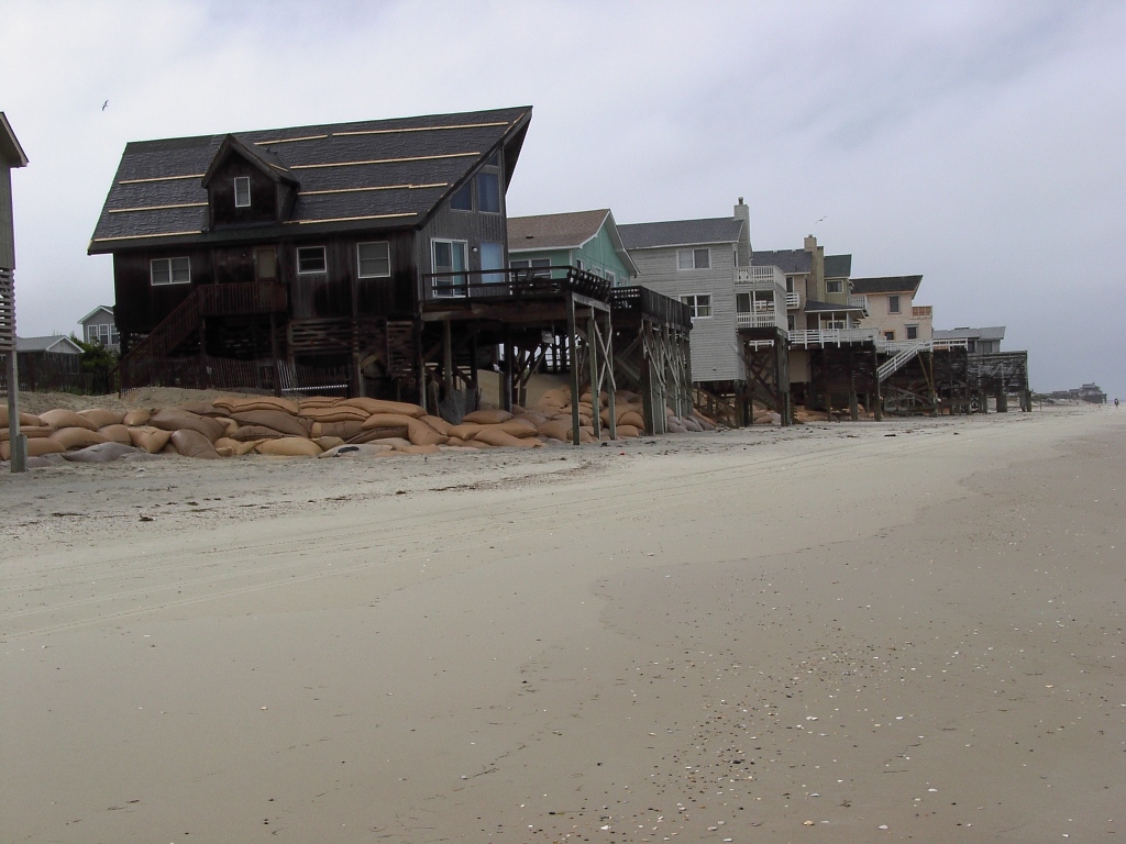 Photo 21. Geotextile sand bags along the beach in Nags Head, North Carolina. Although the homes were on pilings, the geotextile sandbags were needed to protect the septic tanks. (June 2003). [Photo source: ©James G. Titus, used by permission]. |
The Texas Open Beaches Act prohibits private shore protection structures[167] as part of its rules designed to enhance public access to beaches along the Gulf of Mexico.[168] As we discuss in the next section, Texas has consciously pursued a rolling easement policy for decades. But the Open Beaches Act does not prohibit all shore protection. Adding sand to the beach stabilizes the shore but retains an open beach. Regulations that implement the act explicitly recognize approved beach nourishment projects[169] and allow certain small-scale projects.[170]
3.1.2.2 Public Access and the Removal of Structures from the Beach
States can ensure that public access migrates inland either by preventing new construction and requiring removal of old structures that impair access, or by amending state law so that it is clear that public access migrates inland regardless of how the public access was obtained.[171] States often are engaged in a debate about whether homes should be abandoned when storms leave them seaward of the dunes. A common request from homeowners is permission to temporarily place geotextile sand bags in front of their homes, until the government rebuilds the beach, the beach recovers naturally, or the home is destroyed by a severe storm or continuing erosion (see Photo 21). State agencies generally decide whether to grant such permits.[172]
Texas is unique in its efforts to preserve public access along eroding shores. The Texas Open Beaches Act[173] codifies the rolling easement as part of its rules designed to ensure that the public has unfettered access to the dry sand beaches along the Gulf of Mexico.[174] Since before statehood, people walked, rode stage coaches pulled by horses,[175] or drove automobiles over dry sand beaches as if they were public lands. Texans commonly assumed that those beaches were owned by the public,[176] but in 1958 the Texas Supreme Court held that the boundary between private and public land[177] is the mean high tide line,[178] which is seaward of all the dry sand beaches and regularly overwashed by waves.[179] Some owners began building fences across the dry sand beach, which alarmed the public.[180]
Shortly thereafter, the Texas Legislature enacted the Open Beaches Act.[181] The act prohibits fences or any structure seaward of the dune vegetation line in those beaches where “the public has acquired a right of use or easement to or over the area by prescription, dedication, or estoppel, or has retained a right by virtue of continuous right in the public since time immemorial as recognized by law or custom.”[182] Courts have found that the widespread use of the beaches for transportation and recreation created a public easement to the dry sand beach in most populated locations.[183]
|
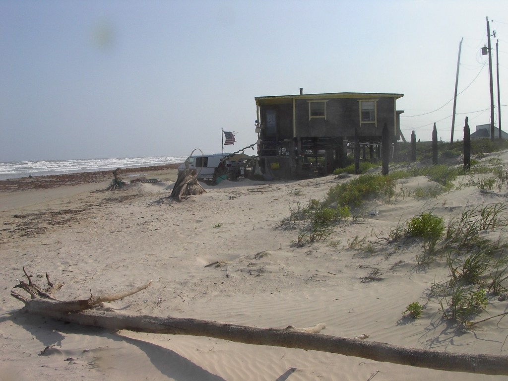
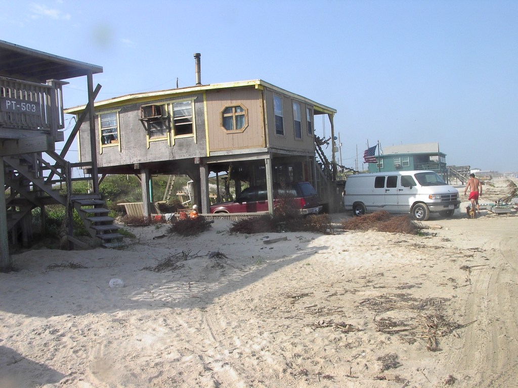 Photo 22 and 23. Two Views of House Encroaching Seaward of the Vegetation Line along the Texas Gulf Coast. Surfside, Texas (May 2003). The beach was the primary means of access. Although these homes were subject to removal orders, the state did not actively seek removal. The homes were destroyed by Hurricane Ike in 2008. [Photo source: ©James G. Titus, used by permission]. |
Enforcement of the Open Beaches Act eventually led to the recognition of a rolling easement along parts of the Texas Gulf Coast.[184] The act allows the state to require removal of structures originally built landward of the vegetation line once that line migrates inland of the structure.[185] It authorizes the General Land Office (GLO) to order removal of any structure that interferes with public use of the beach or threatens health and safety.[186] If the vegetation line migrates inland of a pre-existing structure (see Photos 22 and 23), then the GLO sends a notification to the owner that the structure is subject to an order to remove. Homes are rarely removed because of such orders, but the absence of shore protection makes removal by storms inevitable along the hurricane-prone Gulf Coast as shores continue to erode. The decision to seek removal is discretionary[187] and is sometimes based on whether the home significantly blocks public access[188] (e.g., the home is in the middle of the drivable part of the beach). The statute also gives the GLO the ability to suspend this order for two years if storm erosion leaves a house seaward of the vegetation line, provided that the house is less than 50 percent destroyed, still on private property (i.e., landward of the mean high tide line), and not a threat to health and safety.[189] Administrative rules allow property owners to reclaim as much as 30 feet of the beach by rebuilding dunes after a storm.[190]
Although the Open Beaches Act does not use the term “rolling easement,” court opinions interpreting the act's provisions have held that there is a rolling easement along some (but not all) of the coast. A trial court in Galveston originally used the term in 1964 to describe the seaward migration of public access along an accreting beach near a jetty at the entrance to Galveston Bay.[191] In 1986, the Texas Court of Appeals endorsed the state's rolling easement theory that the public's access along a privately owned beach migrates inland as the beach retreats.[192] For the next 25 years, courts and litigants generally assumed that the rolling easement applies to all beaches in Texas with public access.[193] But in 2010, the Texas Supreme Court held in Severance v. Patterson that the act does not necessarily create a rolling easement along the dry beach on West Galveston Island, or other places where the access has been obtained by means other than the public trust doctrine.[194] If the vegetation line retreats suddenly during a storm (i.e., avulsion), then public access does not retreat.[195] If the vegetation line retreats gradually, then public access migrates inland within a given parcel,[196] but it does not migrate onto the next property back from the shore. [197] The court left open the possibility that the state could order removal of homes on the beach for traditional health and safety reasons.[198]
3.1.2.3 Public Access along Armored Shores
If seawalls and other hard shore protection structures are unavoidable, a rolling easement can still be designed to preserve public access along the shore. Whenever a state issues a permit for a shore protection structure, it can require as a condition the dedication of a public path just inland of the new structure. New Jersey follows this approach, requiring public paths to be constructed along the waterfront inland of new bulkheads and revetments in some locations.[199] In Texas, the Legislature has specifically provided for access to be preserved inland of a few seawalls by defining the vegetation line (seaward of which the public has access) as being landward of the seawalls.[200] (See Photo 24.) As we discuss in Chapter 2, a few other states have policies to prevent private shore protection structures from eliminating public access,[201] and Maryland takes the position that shoreline armoring does not eliminate the right to walk along the shore (although public access may require walking on a stone revetment).
[202]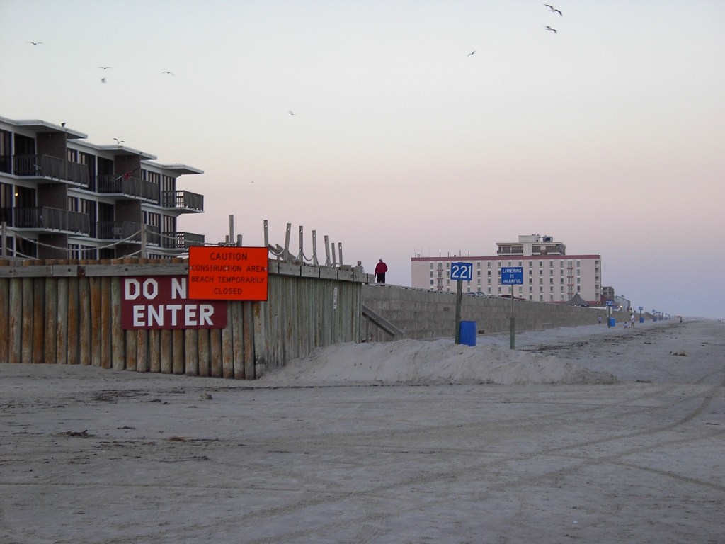
[154] E.g.
Hope, Inc. v. County of DuPage, Ill., 717 F. 2d 1061,
1077 (7th Cir. 1983) (citing Euclid v. Ambler Realty Co., 272 U.S. 365, 47 S.Ct. 114, 71 L.Ed. 303
(1926)). See also 83 AM.
JUR. 2d Zoning and Planning § 9 (2005).
[155]See
Slade et al, supra note 34, at 44 n.58 (listing cases from all 23 tidewater
state courts defining the landward boundary of the public trust). In
[156] See e.g., CCSP, supra note 3, at 226–227 (Maryland); id. at 206–209
(New Jersey); and California Coastal Commission, California Coastal
Commission: Why It Exists and What it Does (2008).
[158] NJAC
§ 7.7E-7.11(e).
[159] Cal. Pub. Res. Code
§ 30235. By “existing structures,”that statute means those built before the
statute was passed in 1976. See generally Todd T. Cardiff, Conflict in the
California Coastal Act: Sand and Seawalls, 38 Cal. W. L. Rev. 255
(2001); and Meg
Caldwell? & Craig Holt Segall, No Day at the Beach: Sea Level Rise, Ecosystem Loss, and
Public Access along the California Coast, 34 Ecology L.Q. 533,
546 (2007). The California Coastal Commission has a wide range of possible tools for
limiting the extent to which future development and redevelopment makes shore
protection likely. Id. at 544–550.
[161] E.g.,
Rhode Island Coastal Resources Management Program §§ 210.3(B)(4) and
210.3(C)(3) (prohibiting structural shore protection to allow wetlands to
migrate inland as sea level rises); and 06-096 Me. Code R. §355 (5) (requiring all projects to be
located and designed based on shore erosion and flooding from a 2-foot rise in
sea level).
[163] See Maryland law review,
supra
note 7, at 1302–03 n. 87; 1309 n. 121; 1368 n. 367; 1376
n. 407; and 1377 n. 412. See also Md. Code Ann. Envir. §16-201 (1998), substantially amended in 2007.
[164] Whether
such a statute would pre-empt rolling easement zoning is unclear. The statute
does not guarantee a right to elevate land surfaces or force localities to
elevate roadways, so it seems possible that a locality could enact rolling
easement zoning and enforce some restrictions while being unable to enforce
other restrictions (unless the statute was amended).
[165]
See infra note
286 and accompanying text (discussing Calvert County
cliff retreat policy). The Calvert County Cliff retreat policy can be reconciled
with the statutory right to shore protection in Md. Code Ann. Envir.
§16-201 (2009).
The county requires landowners to allow the cliff to retreat, while the state
provides the right to protect the shore, which is below the base of a cliff. One
could build a revetment to protect the base of a cliff while enabling the cliff
itself to retreat. This is rarely done because owners are primarily concerned
with the land and buildings at the top of the cliff. Moreover, these local
regulations were designed to further the objectives of the Endangered Species
Act which would preempt the state law. But cf. note 286 (discussing plans to relax rules prohibiting
cliff armoring).
[166] House Bill 973-1978, codified
in Md. Code Ann. Envir.
§16-201(c)(1)(i). See also Maryland Department of the Environment, Proposed Living Shoreline Regulations (2010). When this publication went to press, the state
had not yet published the final regulations.
[167] Tex. Nat. Res. Code Ann.
§ 61.013.
[168] Id. § 61.011(a)..
[169] 31 Tex. Admin. Code § 501.26.
[170] Id. § 15.12(f).
[171]
Statutes that change littoral property rights sometimes
require compensation; conversely efforts to avoid taking property sometimes
prevent the goals of a statute from being achieved. Compare Stop the Beach Renourishment, Inc. v. Florida
Department of Environmental Protection, 130 S. Ct. 2592, 2599, 560 U.S. __, __–__ 2010
(discussing a Florida statute that changed coastal property rights) with Severance v
Patterson, No. 09-0387 (Tex. 2010) (citing statutory provision that
explicitly disclaims any intent to "take rights from private owners” or
affect land titles in any way). See infra § 4.1.3 for additional discussion of regulatory takings of
property.
[172] See, e.g., Tex. Admin. Code
501.26(b); Shell Island Homeowners Ass'n v. Tomlinson, 517
S.E. 2d 401, 403 (NC 1999); and Maryland Law Review, supra
note 7, at 1377 (discussing denial of a request for a
permit to place geotextile containers along a beach in South Carolina).
[173] Tex. Nat. Res. Code
Ann. § 61.011(a).
[174]The statute's
explicit prohibition of hard structures, procedures for removal of homes seaward
of the vegetation line, and explicit recognition of the inland migration of
public access are all characteristics of a “rolling easement”as we use the term
in this handbook. Texas courts have often used the term to narrowly refer to the inland
migration of the public right to access along the privately owned dry
beach. The
extent to which the Open Beaches Act codified that aspect of a
rolling easement has been litigated extensively, and was limited by the Texas
Supreme Court in Severance v Patterson, No. 09-0387 (Tex. 2010) (“[E]existing public easements in the dry
beach … do not migrate or roll landward to encumber other parts of the parcel or
new parcels….”).
[175] Seaway Co. v. Att'y
Gen. 375 S.W.2d 923, 936–37 (Tex. Civ. App., writ ref'd n.r.e.).
[176] Mike
Ratliff, Public
Access to Receding Beaches, 13 Hous. L. Rev. 984, 993–94 (1976).
[177] Luttes v. State,
324 S.W.2d 167, 187 (Tex. 1958).
[178] For
grants before Texas' independence from Mexico, the high tide line refers to mean
higher high water. Luttes 324 S.W.2d at
167, 191. For later grants, it is mean high water. Id. at 169. In most locations,
every other high tide is higher than the previous tide. Mean higher high
water is the average of all the higher high tides, while mean high water is the
average of all the high tides.
[179] See § 2.2.1, supra, for an
illustration and definition of the mean high water line, dry beach, and related
terms.
[180] Ratliff, supra note 176, at 993–94 .
[181] Tex. Nat. Res. Code
Ann. § 61.011(a).
[182]
Id. § 61.013.
[183] See, e.g., Seaway Co. v. Att'y Gen., 375 S.W.2d 923, 936–37
(Tex Civ. App. 1964, writ ref'd n.r.e.); Matcha v. Mattox, 711 S.W.2d 95, 101 (Tex. Civ. App, 1986 writ
denied); and
Feinman v.
State, 717 S.W.2d 106, 113 (Tex. App. 1986, writ ref'd n.r.e.).
[184] Feinman, 717 S.W. 2d at 110–11.
[185] Id.
[186] Tex. Nat. Res. Code
Ann. § 61.0183(a) and § 61.018(a).
[187] Id. § 61.013(b).
[188] Brannan v. State, No. 01-08-00179-CV
(Tex. App.-Houston [1st Feb. 4, 2010, pet. filed).
[189]
Tex. Nat. Res. Code Ann.
§ 61.0185.
[190] Id. §§ 15.13(e)(13) and 15.13(g)(1). The fill may extend up to five feet seaward of the home.
Tex. Admin. Code. §§ 15.13(f)(3–4).
[191] “The Galveston
court described the area subject to public rights as a shifting and rolling
easement.” P. Burka, Shoreline Erosion: Implications for Public Rights and
Private Ownership, 1 Coastal Zone Management Journal 175, 182–83 (1974)
(citing Galveston East Beach, Inc. v. State of Texas, No. 97,893 (10th Dist. Ct. Galveston County, Texas 1964)).
[192] Feinman v.
State, 717 S.W.2d 106, 108–111 (Tex. App. 1986, writ ref'd n.r.e.).
[193] See e.g. Matcha v. Mattox, 711 S.W.2d 95, 101 (Tex. Civ. App. 1986, writ
denied); Feinman, 717 S.W.2d at 113, and Brannan v. State, No. 01-08-00179-CV,
(Tex. App.-Houston [1st Dist.] Feb. 4, 2010, pet. filed). See also Severance v. Patterson,
566 F. 3d 490, 493, 499 (5th Cir. 2009).
[194] “The State cannot declare a public right so
expansive as to always adhere to the dry beach even when the land the easement
originally attached to is eroded … We have never held the dry beach to be
encompassed in the public trust . . . ” Severance v Patterson, No. 09-0387
(Tex. 2010) “A few states have declared that long-standing
property principles give the state (and therefore, the public) the right to all
beachfront property or the right to use even privately owned beachfront property
… [u]nlike the West Beach of Galveston … [where] private owners who purchased
beach properties obtained title without limitation on private rights of
ownership and without encumbrances for public use.”Id. Texas common law applies to lands that became
privately owned after Texas became independent from Mexico. This case did not
address land granted before Texas Independence, where the Spanish civil law
applies.
Id. § 2.
[195] “Although existing public easements in the dry beach of Galveston's West Beach are dynamic … these easements do not migrate or roll landward to encumber other parts of the parcel or new parcels as a result of avulsive events.”Id.
[196] “Easements for public use of private dry beach property do change along with gradual and imperceptible changes to the coastal landscape.” Id.
[197] “New
public easements on the adjoining private properties may be established if
proven pursuant to the Open Beaches Act or the common law.”Id.
[198] The
rolling easement would still apply to the boundary between public and private
land (i.e., the high tide line). The case only concerned lands conveyed after
Texas Independence (common law), id. leaving open whether the rolling easement still
applies more generally to lands conveyed during Mexican rule (civil law).
[200] Tex. Nat. Res. Code Ann.
§ 61.017(c) (providing for public access inland of seawall on North
Padre Island in the aftermath of State of Texas v. Padre Island Development Corporation
(28th Judicial District, July 29, 1974); Tex. Nat. Res. Code Ann.
§ 61.017(d) (providing for public access landward of a revetment
constructed by the Corps of Engineers).
This page contains a section from: James G. Titus, Rolling Easements, U.S. Environmental Protection Agency. EPA-430-R-11-001 (2011). The report was originally published by EPA's Climate Ready Estuary Program in June 2011. The full report (PDF, 176 pp., 7 MB) is also available from the EPA web site.
For additional reports focused on the implications of rising sea level, go to Sea Level Rise Reports.